
|
J. M. Bonnet-Bidaud, F. Praderie, S. Whitfield |
The Dunhuang Chinese Sky, VII Sec. d. C., Cina |
The Dunhuang Chinese Sky, VII Sec. d. C., Cina
(Journal of Astronomical History and Heritage 12:39-59,2009)
FILMATO
Si ringrazia
Journal of Astronomical History and Heritage
National Astronomical Research Institute of Thailand. (NARIT)
![]()
The British Museum
The British Library
Jean-Marc Bonnet-Bidaud is an astrophysicist in the Astrophysical Department of the French Atomic Energy Commission(C.E.A.), and specialises in high energy astrophysics and in the study of highly condensed stars in the Galaxy. He is also deeply interested in the history and popularisation of astronomy. He is currently the scientific adviser of the French astronomy magazine Ciel et Espace and has published numerous articles in different magazines and newspapers. He is mainly interested in the history of modern cosmology and in the roots of ancient astronomy in China and Africa.
Dr Françoise Praderie, an outstanding European astronomer, passed away on 28 January 2009, before this paper was published. Prior to that she was an Honorary Astronomer at the Paris Observatory. She was a former Vice-President of the Paris Observatory and former Editor of Astronomy and Astrophysics. She contributed to the creation of the trans-disciplinary European association Euroscience, where she served as its first Secretary General. Her main research interests are in stellar seismology, and she was the author of the book The Stars (which was co-authored with E. Schatzman).
Dr Susan Whitfield is Director of the International Dunhuang Project at the British Library and an historian and writer on China and the Silk Road. She is interested in cross-disciplinary research, combining history, archaeology, art history, the history of religions and science in her study of manuscripts and artefacts from the eastern Silk Road. She has published extensively, lectures worldwide and also has curated several exhibitions, including a display of historical star charts in the collections of the British Library.
This paper presents an analysis of the star atlas included in the medieval Chinese manuscript Or.8210/S.3326 discovered in 1907 by the archaeologist Aurel Stein at the Silk Road town of Dunhuang and now housed in the British Library. Although partially studied by a few Chinese scholars, it has never been fully displayed and discussed in the Western world. This set of sky maps (12 hour-angle maps in quasi-cylindrical projection and a circumpolar map in azimuthal projection), displaying the full sky visible from the Northern Hemisphere, is up to now the oldest complete preserved star atlas known from any civilisation. It is also the earliest known pictorial representation of the quasi-totality of Chinese constellations.
This paper describes the history of the physical object — a roll of thin paper drawn with ink. We analyse the stellar content of each map (1,339 stars, 257 asterisms) and the texts associated with the maps. We establish the precision with which the maps were drawn (1.5-4° for the brightest stars) and examine the type of projections used. We conclude that precise mathematical methods were used to produce the Atlas. We also discuss the dating of the manuscript and its possible author, and we confirm the date +649-684 (early Tang Dynasty) as most probable based on the available evidence. This is at variance with a prior estimate of around +940. Finally, we present a brief comparison with later sky maps, both from China and Europe.
The Dunhuang star atlas is one of the most spectacular documents of the history of astronomy. It is a complete representation of the Chinese sky including numerous stars and asterisms depicted in a succession of maps covering the full sky (Figure 1). Apart its aesthetic appeal, the document found on the Silk Road is remarkable as it is the oldest star atlas known today from any civilization.
The Dunhuang star atlas is unique in the information it gives, which is discussed in more detail below: a) more than 1300 individual stars in the total sky are represented, as could be observed by eye from the Chinese imperial observatory; b) the sky is displayed as in the most modern charts with twelve hour-angle maps, plus a North polar region; c) the Chinese constellations are indicated with their names; d) the atlas is drawn in two inks on the finest paper and accompanied with complementary text; e) the document is shown to date from the early Tang period (618-907), while the oldest other star atlases in China date from the eleventh century.
The manuscript is very often quoted in encyclopaedic and popular publications as an illustration of Chinese astronomical knowledge. However, despite its crucial historical and scientific importance, we realized that no extensive description and analysis of the atlas existed in Western literature. Needham reproduced part of the manuscript and gave only a very short description (Needham, 1959, 264). Since then it has received only brief mentions in other studies (Sun Xiaochun and Kistemaker, 1997, 29; Deng Wenkuan and Liu Lexian, 2003, 76).
We decided to undertake a detailed study of the star atlas after the exhibition on the Silk Road organised in 2004 by the British Library where the document was shown and a preliminary analysis was given (Bonnet-Bidaud and Praderie, 2004). In the present paper, we shall first give a full review of the Chinese sources (sect. 2), then give a general description of the star atlas (sect. 3), examine the accuracy and the type of planar projection used and also present a method to give a date from astronomical arguments (sect. 4). We then discuss the date of the star atlas, compare the Dunhuang star atlas to other Chinese atlases and further comment on the status of these documents (sect. 5). In a monographic appendix, we also include the in-depth description of two representative sections of the document. This study was made possible by the use of high resolution digital copies of the star atlas made available to us by the International Dunhuang Project1. This first publication in Western language is aimed at making available basic information on this important document.

Figure 1: The complete Dunhuang Star Atlas, the last section of the Or.8210/S.3326 British Library manuscript, showing the twelve star maps (as seen above, from right to left), followed by the circumpolar map and ending with the drawing of a bowman in traditional clothes. The total dimensions are 2100 mm in length and 244 mm in width.
Inscribed on a roll of Chinese paper, the manuscript star atlas is surprisingly well preserved. The conditions in which the document was found are well known and leave no doubt about its antiquity. It was discovered by the British-nationalised but Hungarian-born archaeologist Aurel Stein in 1907 among the pile of at least 40,000 manuscripts (Hamilton, 1986) enclosed in the so-called Library Cave (Cave 17) in the Mogao ensemble, also known as the ‘Caves of the Thousand Buddhas’ near Dunhuang (Gansu). The Mogao caves are a set of several hundred Buddhist temples cut into a cliff and heavily decorated with statues and murals. The site was active from about +3602 to the end of the Mongol period. In about +1000, one cave was apparently sealed (Rong Xinjiang, 1999) to preserve a collection of precious manuscripts and some printed material including the world’s earliest dated complete printed book (Whitfield and Sims-Williams, 2004). The sealed cave was rediscovered by accident and re-opened only a few years before the arrival of Stein in 1907. He was therefore the first European visitor to see the hidden library.
These circumstances, together with the dry desert climate of Dunhuang, contributed to excellent conservation of the cave’s contents. Most of the Dunhuang documents are religious texts on Buddhism but there are some socio-economic documents and a few concern medicine, divination and astronomy (Kalinowski, 2003). The astronomical texts are all calendars or almanacs except for two star charts. One of them contains the representation of the whole sky as it could be observed from a latitude of ~ 34°N. This is now known as the Dunhuang star atlas. The other (probably only a fragment) represents incompletely the polar region but not the rest of the sky. This other chart (DB 76) is preserved in the Dunhuang City Museum in China.
After the visit of Stein and the subsequent visits of other foreigners such as Paul Pelliot, Otani Kozui and Sergei Oldenburg, as well as the clearing of the cave by the Chinese government, the manuscripts were dispersed to England, France, China, Russia and Japan.3 Stein’s collections were transferred to the British Museum, where the Dunhuang star atlas received the registration number Or.8210/S.3326 (S. for Stein, hereafter referred to as S.3326).4
S.3326
did not receive much attention at the time of its discovery. This manuscript,
which is in two sections, was catalogued by Lionel Giles (Giles, 1957). He
listed it under the classification 'divination'
(cat.
no. 6974) for the first section and described the second section as '13
star-maps with explanatory text'
. He did not estimate a date. His catalogue
was published in 1957 but it had been ready for publication since 1947.5 Around
the earlier date, Joseph Needham and Chen Shixiang studied the Stein collection
of astronomy-related manuscripts for their volume on astronomy (Needham, 1959).
In a footnote in the volume, Needham (1959: 264) claims to have been the one to
recognize the worth of the star atlas: 'I
discovered this extremely interesting map in conjunction with my friend Prof.
Chhen Shih-Hsiang.'
He is
also probably responsible for the initial dating of this manuscript, quoted in
most studies thereafter, as he continues: 'Its
probable date makes it about contemporary with the maps in the Book
of the Fixed Stars… (+903 to +986…)'
and
he puts the date at 'ca.
+940'
in his text and
captions to the reproduced images (his Figs. 99 and 100).
Unfortunately, the Needham archives do not yield any further information about Needham’s visit to the British Museum to view the manuscripts, nor his research notes. The astronomy volume was published in 1959 but most of the work was carried out between 1949-56, when the manuscript for this volume was completed. It is probable therefore that the 'discovery' was in the early 1950s. By this time, Giles had completed work on his catalogue, although it was still unpublished, and could have directed Needham to the astronomy-related manuscripts.
Although we know that the sky was carefully observed for at least four millennia in China, India and Mesopotamia, what remains in written or graphical form of these observations is very patchy. China is noticeable, though, since astronomical chapters can be found in every of the official dynastic historical records starting in the second century BCE with the Historical Records (Shiji 史记)6 of Sima Qian (司马迁) (Chavannes, 1895), generally considered to be the first history of China. The astronomical chapters of the Shiji include stellar catalogues, which are copies of older, lost ones composed during the Warring States period (-476 to -221). They are known to result from different schools led by three astronomers of ancient times Shi Shen (石申), Gan De (甘德) and Wu Xian (巫咸) who composed reference books describing the stars and the different astrological predictions associated with them (Chavannes, 1895; Maspero, 1929). Though Sima Qian himself does not differentiate information from the three schools of astronomers, the three distinct catalogues were maintained through the Han period (-206-+220) and later combined by the astronomer Chen Zhuo 陈卓 (+220–280). The tradition of attributing each asterism (or Chinese constellation) to a different school survived because of the demands of astrological prediction.
The most complete and detailed description of the Chinese sky, including positions, given by coordinates in Chinese degrees, is later found in the Astrological Treatise of the Kaiyuan Period (Kaiyuan Zhanjing 开元占经), a compilation attributed to the astronomer Qutan Xida (瞿坛悉达) in +729. Part of this information is also present in the astronomical chapters of the History of the Jin (Jinshu 晋书) and History of the Sui (Suishu 隋书), both probably written by the astronomer Li Chunfeng 李淳风(+602–70) (Needham, 1959, 197, 201 ; Ho, 1966).
Chinese astronomy differs from the ecliptic-based Chaldeo-Greek tradition by its equatorial character, due to the central role of the polar star (Biot, 1862; de Saussure, 1930). The celestial region close to the equator is divided in 28 asterisms (group of stars), called xiu (宿), and often translated as 'mansions' or 'lunar lodges' (hereafter referred to as 'mansions'), which can be considered as an equatorial Chinese zodiac.7 A mansion is defined by an hourly interval corresponding to the meridian passage of two successive leading stars. The grouping of the stars in China is also totally different from the Greek tradition. Beside the equatorial region, the rest of the sky is divided in very numerous small asterisms (nearly three hundred), most associated with practical objects or persons of the Chinese empire, leading to astrological predictions. Lists of the Chinese constellations were maintained all through Chinese history and did not change much over time. They form the basis of the astronomical Chinese tradition (Ho, 1966; Sun and Kistemaker, 1997).
Based on different photographic reproductions, Chinese scholars, both historians and astronomers, have produced several papers in Chinese on S.3326 since the 1960s. Xi Zezong first published an article with complete images (1966). He probably used facsimile images of S.3326 taken from the microfilm. He emphasizes the progress represented for the first time by the representation of the sky charts not on a circular plan but in a way similar to the Mercator projection, several hundred years before Mercator. He notes that the column texts accompanying each hour-angle map are similar to the ones found in the chapter 64 of the Kaiyuan Zhanjing and provides more complete versions based on this text. He then describes the hour-angle maps and the circumpolar map, giving the number of stars by asterism, with asterisms being ordered according to the mansions. He counts 1,359 stars in total and compares it to the Chen Zhuo list giving 1,464 stars following a compilation of the catalogues of Shi Shen, Gan De and Wu Xian (Needham, 1959, 265).
Ma Shichang (1983) paid particular attention to the dating of S.3326. While Needham (1959) mentions, without any justification, a date of ca. +940, Ma Shichang analyzes three elements in the document: a) the style of writing, b) the clothing of the bowman whose drawing ends the manuscript, and c) the taboo characters in the text.8 He cites the taboo form of the character 民 (min) to infer that the manuscript was copied after the reign of Li Shimin (李世民), the personal name of the Taizong emperor (r. +626-49). He argues further that since the character 旦 (dan) occurs several times, the manuscript was written before the reign of the Ruizong emperor ( i.e. before +710), who had this character as his personal name, Li Dan (李旦). Starting with his reign, the character 旦 should have been replaced. Ma Shichang narrows the time gap further by using the type of clothes worn by the bowman (see also sect. 5.1), saying that this type was in use only since the time of Empress Wu Zetian (r.+690-705). Since the manuscript has no Empress Wu taboo characters, it had to be written after her reign, i.e. after +705. From this evidence he concludes that S.3326 was written in ~+705-710. His argument, however contains inconsistencies (see sect. 5.1).
Pan Nai (1989, 148) also produced a description of S.3326 with a valuable discussion on its date. , there is a possible reference to Li Chunfeng. He refutes the claim (Xia, 1982) that S.3326 was inspired by Songs of Pacing the Heavens (Bu Tian Ge (歩天歌) (Iannaccone, 2002; Zhou, 2004), a book in verses including some sky illustrations which is dated +590-600. Pan Nai supports the idea that there was an original star atlas prepared by Li Chunfeng from which S.3326 was copied. Considering the style of writing of the accompanying text, he proposes without any further argument that the copy may date from the tenth century, thus concurring with Needham (see also sect. 5.1).
Deng Wenkuan (1996: 58ff), in the context of a study of astronomical texts and calendars found in Dunhuang, reproduces the S.3326 star atlas with explanatory notes and punctuated versions of the text. In a more recent book (Deng, 2002), he dedicates a chapter to S.3326 and finds similarity with several other texts such as the astronomical chapters of the Jinshu, another text by Li Chunfeng (Yisi Zhan 乙巳占) and the Kaiyuan Zhanjing.
In a book on ancient Chinese star atlases, Feng Shi also gives a brief survey of S.3326 (Feng, 2001, 330).
S.3326, now held at the British Library, is a paper scroll of total length 3940mm and width 244mm. It is in reasonable condition. The thickness of the original paper is about 0.04mm (0.16mm with the modern lining). The manuscript is currently wrapped in a silk wrapper and supported by a wooden roller, both being later additions. The Chinese paper is very fine and a recent analysis revealed that it is made of pure mulberry fibres.9 The scroll is fully lined with a brown Kraft paper.10 The lining on the object is a treatment performed in the 1950s, its style and materials being consistent with the type of interventions performed during that period and the following decade at the British Museum. The microfilm provides further evidence. This was shot in 1953 and shows the manuscript already lined. It is possible that the Kraft paper lining was only added to the manuscript after Needham’s discovery. It is clear that those items in the Stein Collection receiving the most attention from scholars were those that received conservation treatment. The remainder were largely left in their original condition.
The
scroll is inscribed on one side only. The beginning of the scroll is however
missing so that there is no title or names of the authors. The bottom section is
also missing at the beginning of the document. In some parts, there are traces
of replication marks by contact due to the long conservation in a rolled state.
The document is divided in two different parts. From right to left, the first
section is an uranomancy/meteoromancy text containing 80 extant columns of text
below 26 drawings of clouds of different shapes. In this part there is an
interesting citation under column 43 which can be translated as 'according
to your servant Chunfeng'
(Pan,
1989; Deng and Liu, 2003), a possible direct reference to the astronomer Li
Chunfeng. Lü Buwei 呂不韋 (c.–291–235),
advisor to the First Emperor of China, Qin Shihuangdi, is also mentioned (Figure
2; see
also sect. 5.1).
The star atlas follows this first section without a break. The atlas is 2100mm in length and consists of 12 vertical maps, each with accompanying texts in columns on the left, followed with one map of the circumpolar region with no text, and one column at the end, making 50 columns and 13 maps in total. The full star atlas is presented in Figure 1. The very last part of Figure 1is the drawing of a bowman shooting an arrow in traditional clothes and, judging by the caption to his right, this depicts the god of lightning. He is followed by what appears to be a title (to his left). It is common in Chinese manuscripts to note the title at the beginning and end of the document so it is probable, therefore, that this text refers to the previous parts. However, the meaning of this title remains a mystery and it has not yet been possible to make sense of it;11 moreover a survey of Chinese historical and bibliographical sources failed to reveal a similar title.

Figure 2: Part of the S.3326 first section (cloud divination texts). Columns 41 to 44 are shown, 41 to the right. The text (fully translated in Section 5.1 in the present paper) includes a reference to the possible author of S.3326, the astronomer Li Chunfeng (text in red frame).
The twelve star maps are arranged in separate hour-angle sections, beginning with the mansions of Xu(虛) and Wei (危) and covering the entire sky, namely the 28 mansions and their North and South prolongations, by slots of about 30° in the East-West direction. In each map, the Chinese asterisms with their names are drawn from stellar declination about - 40° to about + 40°. The stars are shown as coloured dots, the majority of which encircled in black. All dots are of similar size. Black lines joining the dots materialize the constellations or asterisms. The orientation is such that North is up and West is at right so that the star right ascensions (or celestial longitudes) grow from right to left in the direction of the document. The celestial equator and the ecliptic are not represented and the Milky Way is not apparent. There is no coordinate grid either. The thirteenth and last map is the North circumpolar region, represented as a planisphere of radius about ~40° i.e. covering the declination zone from 90° to 50°. Obviously, the 12 maps are limited towards South by the visibility above the horizon of the night sky, from the Imperial Observatory which might have been in Chang’an (present-day Xi’an) or Luoyang, both at latitude of ~34° N.
Noticeably,
S.3326 records however the presence of several very southern objects, hardly
observable from Chang’an or Luoyang. On the map corresponding to the fifth
lunar month (map 6), the star Laoren老人 (α
Car-Canopus) is displayed, though misplaced towards the north and closer to the
equator than it is in reality. Despite its southern position, the star is also
included in Sima Qian’s astronomical chapter. He indicates it symmetrically
about Tian Lang 天狼 (α
CMa-Sirius) as 'a
big star called "the old man of the south pole" (Nanji Laoren 南极老人)'
.
Also shown, are the very southern stars, Beiluo
shimen 北落师门 (map
1- α PsA) and Nanmen 南门 (map
9 - two stars of Centaurus), also reported by Sima Qian. This shows that Chinese
astronomers explored the Southern sky and had done so long before the known
southern expedition of +724-725. It was led by Yi Xing 一行 (+683–727),
a Tang astronomer who re-measured the positions of many stars in the Chen Zhuo
list and established at least eleven observation stations, down to latitude 17.4°
near Hué in present-day Vietnam (Beer et al, 1961).
The individual stars appear to have been taken from a composite catalogue, established by the astronomer Chen Zhuo by merging the observations of the “Three Schools” astronomical tradition (see sect. 2.1). Although the Chen Zhuo catalogue, which is also said to have contained a star atlas (Ho, 1966, 67) is lost, Kaiyuan Zhanjing has preserved the list of constellations of the Three Schools, with 1464 stars grouped in 283 asterisms. S.3326 contains similar information and is the first known document which shows stars as different coloured dots to differentiate between the astronomers of the Three Schools: Shi Shen (red), Gan De (black) and Wu Xian (white and/or yellow). Here the colour conventions are grosso modo followed. There are many changes however, which suggests that this tradition was less rigidly followed at the time S.3326 was drawn. We have counted 1339 stars grouped in 257 asterisms, although some overlapping or some non-encircled dots prevent an accurate census. Xi Zezong (1966) gives for the same chart a number of stars of 1359. We were able to identify all but fifteen asterisms as their Chinese names are given on the map.
Out of the 28 mansions, 27 are shown on S.3326, as a belt roughly following the celestial equator, and all show up with their leading star. The only missing one is Wei (胃) or belly which may be present in the east part of map 3 but with a character including a mistake. As in the description given by Li Chunfeng in the astronomical chapters of the Jinshu (Ho, 1966), the Chinese sky exhibited by S.3326 displays the three yuan(垣 enclosures or wall systems), namely Ziwei (紫微), Taiwei (太微) and Tianshi (天市), which encircle different groups of stars. These are regions of the present pole star α UMi and stars in Draco and Cassiopeia for Ziwei; β Vir and stars in Virgo forTaiwei; ζ Oph and stars in Ophiucus for Tianshi. All the bright stars visible from latitude 34°N are found on the map. As to the faintest ones, they correspond to eye observations of astronomers with very sharp eyesight. It is puzzling, and noted for a long time, that Chinese astronomers did not pay attention to visual magnitudes when drawing star atlases. This is the case in S.3326, where we estimate that stars as faint as visual magnitude 6.5 are present.

Figure 3: The Orion star map (Map 5, lunar month 4th). The map shows the recognizable Western constellation, Orion, and includes additional calendar texts (on the left) and culmination texts (at the bottom).
The document, drawn by hand and possibly a copy, shows the positions of the stars with, in general, good precision (see sect. 4.1). In Chinese astronomy, the large number of asterisms (257 as compared to the 88 modern constellations) allows to specify fairly well the 'co-ordinates' of mobile heavenly bodies such as the Sun, Moon and five planets or of unexpected events such as 'guest stars' (comets or novae). None of the latter appears on S.3326.
We have noted some misplacements of stars or asterisms, which are either errors or show lack of attention on the part of the copyist. For instance on map 6, the asterism Liu 柳 (part of Hydra) should be at the same declination asNanhe 南 河 (containing α CMi) while on the map Liu is too far to the North. We also note that the same name appears for different groups of stars, but this is in accordance with the Chinese tradition. For instance, Tiantian 天田 denotes an asterism south of the mansion Niu 牛 (map 12) as well as an asterism of 3 stars north of the mansion Jiao 角 (map 9). On map 13, there are also two groups of 3 stars with the same name, Sangong 三公 (Three excellencies), one to the south of the handle of Beidou 北斗 , the other near the star α UMa also in Beidou, but this appears here to be a faulty duplication. Finally there is some confusion between left (zuo 左) and right (you 右) when denoting east and west relative to a given star or asterism. An example is found on map 3, with Yougeng 右更being east and Zuogeng 左更 west of Lou and on map 8 with Youzhifa east andZuozhifa west of Taiwei 太微 (β Vir). This seems in both cases an error of the author of the S.3326 map, an error which is not repeated on map 12 where Youqi 右旗 is west and Zuoqi 左旗is east.
Two representative maps, the Orion stellar region (map 5, Figure 3) and the circumpolar region (map 13, Figure 4) are fully described in the Appendix.
Each of the twelve hour-angle maps comes with an explanatory text in one or two columns located to the left. The north polar map has no such text.
The texts are a description of the twelve divisions of the Chinese year with their associated astrological predictions. In each map, the equatorial zone (including classically 2 or 3 mansions) is defined precisely by its extension in Chinese degrees12 and related to the corresponding station of Jupiter (the so-called ‘year star’). The sidereal period of Jupiter being 11.86 tropical years, it was approximated to 12 years in Chinese tradition. The sky was therefore divided in twelve sectors, successively occupied by Jupiter in 12 years, and named Jupiter stations (ci 次). Moreover each column text gives two more indications: the name of each terrestrial branch (one element in the enumeration of days in the Chinese calendar) associated with the Jupiter station and the name of the state within the Chinese empire supposedly influenced by that region of the sky (see Table 1). As an example, the first map refers to the Jupiter station Xuan Xiao. The text reads:
From the 8th degree of Nü to the 15th degree of Wei, associated with [the terrestial branch] zi, is [the Jupiter station] Xuan Xiao. The colour of the North direction is the black. When Xu [appears], [it will be] a bad harvest. At the 11th month, the spirit yang contracts, the spirit yin expands, the ten thousand beings [all the creation] disappears into the darkness, there is no life, sky and earth are without consistence, the Sun [goes] into Xuan Xiao. This division corresponds to [the state of] Qi.
These texts are mainly of astrological use but the scientific notation in degrees reveals that they are based on astronomical observations and have been produced with the attempt to be as precise as possible for this period. Interestingly, a reduced version of similar texts is found in the astronomical chapters of the Jinshu with a later redaction commonly attributed to Li Chunfeng. This shortened version includes only the station extensions in degrees, the terrestrial branch and a more detailed association with Chinese states but without any astrological predictions (Ho, 1966: 113-120). We have checked the S.3326 extensions and found them almost exactly the same to those of the Jinshu, with only very minor one-degree variations in three cases (Table 1).
We also note that in five cases (maps 1, 4, 5, 7 and 9), the texts refer to a lunar month different from the corresponding map, in reference with the long astrological tradition of considering a 'shadow planet' moving in the opposite direction of Jupiter (see Needham, 1959, 402).
The astrological comments were found by previous authors analogous to texts in the section Fenye Lueli (分野略例) of the astronomical treatise (chapter 64) of the later Kaiyuan Zhanjing. Based on this complementary information, a completed version in Chinese of the twelve calendar texts was produced, restoring the punctuation and the missing characters since some of the texts seem abbreviated on S.3326 (Xi, 1966; Deng, 1996, 58). The S.3326 texts appear therefore more developed than those found in Jinshu but also a somewhat earlier preliminary version of those of the Kaiyuan Zhanjing.
Analysis of the stations’ equatorial extensions on S.3326 shows that their lengths are approximately equal, with a mean value of 29.0° and a total range from 27.1° to 31.4° (for an equator at date +700). A major difference occurs however for the Jupiter stations Chun Huo (month 6) and Chun Wei (month 7) with respectively an extension of 36.7° and 19.7° (Table 1). This appears to be an error of 10° in the extension of the mansion Zhang that is given as 18° while the mansion total extension is only 8° (the effect of the precession will not vary this value by more than a fraction of a degree even for dates back to 500).
Table 1 shows that the correspondence between Jupiter stations and Chinese mansions on the Dunhuang atlas is almost exactly the same as that found on Figure 91 and Table 34 (Needham, 1959). Actually the repartition of the mansions with respect to the Jupiter stations is conventional and seems to go back to a very old tradition (de Saussure, 1930). As these calendar texts are based on Jupiter cyclic behaviour, they do not provide useful astronomical information on the production date of the document.
| Table 1 : Correspondence between Jupiter stations and Chinese mansions according to the S.3326 maps | |||||||
|---|---|---|---|---|---|---|---|
| Map1 | Month | S.3326 Jupiter Stations |
S.3326 Jupiter Stations Extensions |
S.3326 Chinese mansions2 (from West to East) |
S.3326 Month/Branch/State3 |
Needham Jupiter Stations |
Needham Lunar Mansions4 |
| 1 | 12 | Xuan Xiao | from 8th ° of Nü to 15th ° of Wei | Xu, Wei(12) | 11 / zi / Qi | 5. Xuan Xiao | Nü, Xu, Wei |
| 2 | 1 | Zou Zi | om 16th ° of Wei to 4th ° of Kui | Shi, Bi(14) | - / hai/Wei | 6. Qu Zi | Shi, Bi |
| 3 | 2 | Jiang Lou | from 5th ° of Kui to 6th ° of Wei | Kui, Lou | - / xu/Lu | 7. Jiang Lou | Kui, Lou |
| 4 | 3 | Da Liang | from 7th ° of Wei to 11th ° of Bi | Mao, Bi(19) | 8 / yu / Zhao | 8. Da Liang | Wei5, Mao, Bi |
| 5 | 4 | Shi Chen | from 12th ° of Bi to 15th ° of Jing | Zui, Shen, Jing | 7 / shen/ Wei | 9. Shi Chen | Zui, Shen |
| 6 | 5 | Chun Shou | from 16th ° of Jing to 8th ° of Liu | Gui, Liu | - / wei / Qin | 10.Chun Shou | Jing, Gui |
| 7 | 6 | Chun Huo | from 9th ° of Liu to 17th° of Zhang6 | Xing, Zhang | 5 / wu / Zhou | 11. Chun Xin | Liu, Xing, Zhang |
| 8 | 7 | Chun Wei | from 18th ° of Zhang to 11th ° of Zhen | Yi, Zhen | - / si / Chu | 12. Chun Wei | Yi, Zhen |
| 9 | 8 | Shou Xing | from 12th ° of Zhen to 4th ° of Di | Jiao, Kang | 3/chen/Zheng | 1. Shou Xing | Jiao, Kang |
| 10 | 9 | Da Huo | from 5th ° of Di to 9th ° of Wei | Di,Fang,Xin,Wei(6) | - / mao / Song | 2. Da Huo | Di, Fang, Xin |
| 11 | 10 | Xi Mu | from 10th ° of Wei to 12th ° of Dou7 | Ji, Dou | - / yin / Yan | 3. Xi Mu | Wei, Ji |
| 12 | 11 | Xing Zhi | from 12th ° of Dou6 to 7th ° of Nü | Niu, Nü | -/chou/Wu-Yue | 4. Xing Ji | Dou, Niu |
|
|||||||
At the bottom of the maps, an additional text gives the major tropical landmarks associated with the lunar month. One reads together with the number of the lunar month, the position of the Sun with respect to the mansions present on the map and the culminating constellations at dusk and at dawn during the month. The first map is labelled '12th lunar month'. For three maps (8, 10 and 12), these indications are absent or erased.
The twelfth (lunar) month, the Sun meets the mansions Nü and Xu; at dusk the mansions Kui and Louculminate; at dawn the mansion Di culminates. 十二月 - 日會女虚 - 昏奎婁中 - 旦氐中
The astronomical content of these texts is summarized in Table 2. According to different authors (Pan, 1989; Deng, 2002) these monthly texts are identical to those found in an early text, the Monthly Ordinances (Yueling 月令), that can be found both in the historical text The Spring and Autumn Annals (Lüshi Chunqiu 呂氏春秋), dated -240 and in a chapter of the Classic of Rites (Liji 礼记), dated approximately to the third or second century before the modern era. For comparison, the corresponding information from the Yueling texts is also given in Table 2, according to Legge’s translation (Legge, 1885; also Couvreur, 1913). Despite an overall similarity, there are notable small differences between Yueling and S.3326. For the culminations of mansions at dusk and dawn, the differences only affect months 2, 6 and 10 (out of the 9 months for which these texts are present on S.3326), with at least one obvious copying error (see Table 2).
Interestingly enough, for the Sun conjunction with the mansions, the months 3, 4, 5, 10 and 12 are given with two mansions instead of one, the second one always with a higher right ascension than the mansions in Yueling. If interpreted as corrections to take into account the effect of precession for a period later than that of the Yueling, this is opposite to what would be expected. The culmination texts on the maps can however be dated by comparing with known astronomical configurations (see sect. 4.2).
| Table 2: Culmination texts: positions of the sun and culminations in lunar months | ||||||||||||
|---|---|---|---|---|---|---|---|---|---|---|---|---|
| Map | 1 | 2 | 3 | 4 | 5 | 6 | ||||||
| Lunar Month | 12 | 1 | 2 | 3 | 4 | 5 | ||||||
| Major Western Constellations on S.3326 | Cygnus-Pegasus-Aquarius | Andromeda-Pegasus-Pisces | Aries-Cetus-Andromeda | Perseus-Taurus-Eridanus | Auriga-Orion-Lepus | Cancer-Canis Major-Gemini | ||||||
| S.3326 | ||||||||||||
| Chinese mansions (xiu)1 on S.3326 | Xu Wei (12) |
Shi Bi (14) |
Kui Lou |
Mao Bi (19) |
Zui Shen Jing |
Gui Liu |
||||||
| Sun conjunction | Nü Xu |
Shi | Kui | Wei
(17)2 Mao |
Bi
(19) Zui |
Jing Gui |
||||||
| Dusk culmination | Kui Lou |
Shen | Liu |
erased? | Yi | ?? Kang |
||||||
| Dawn culmination | Di | Wei (6) | Niu | erased? | Nü | Wei (12) | ||||||
| YUELING4 | ||||||||||||
| Sun conjunction | Nü | (Ying)Shi | Kui | Wei (17) | Bi (19) | Jing | ||||||
| Dusk | Lou | Shen | ?? | Yi | Kang | |||||||
| Dawn | Di | Wei (6) | Dou | Niu | Nü | Wei (12) | ||||||
| Map | 7 | 8 | 9 | 10 | 11 | 12 | ||||||
| Lunar Month | 6 | 7 | 8 | 9 | 10 | 11 | ||||||
| Major Western Constellations on S.3326 | Leo-Hydra | Virgo–Corvus–Canes Venatici | Bootes-Virgo-Lupus | Serpens-Ophiucus-Scorpius | Herculus-Ophiucus-Sagittarius | Lyra-Aquila-Capricornus | ||||||
| S.3326 | ||||||||||||
| Chinese mansions (xiu)1 on S.3326 | Xing Zhang |
Yi Zhen |
Jiao Kang |
Di Fang Xin Wei (6) |
Ji Dou |
Niu Nü |
||||||
| Sun conjunction | no text | Jiao | no text | Wei
(6) Ji |
no text | |||||||
| Dusk culmination | Fang | no text | Niu | no text | Kang3 | no text | ||||||
| Dawn culmination | Kui | no text | Zui | no text | no text | |||||||
| YUELING4 | ||||||||||||
| Sun conjunction | Liu | Yi | Jiao | Fang | Wei (6) | Dou | ||||||
| Dusk | Huo/Xin5 | JianXing | Niu | Xu | Wei (12) | Bi (14) | ||||||
| Dawn | Kui | Bi (14) | Zui | Liu | Zhen | |||||||
|
||||||||||||

Figure 4: The North circumpolar region (Map 13). The map displays from the polar region down to a celestial latitude of about +50°.
The circumpolar map is fully described in the Appendix and shown in Figure 3. As was usual in the Chinese sky representations, the North Polar region features the central Purple Palace with the Celestial Emperor at the pole, surrounded by his family, servants, military officers and the corresponding housing.
According to Gaubil, also quoted by de Saussure (Gaubil, 1819; de Saussure, 1930), the star β UMi was adopted as polar star by the Chinese about -1000, and named Di (the first ancestor), but it was distant by 6°30' from the real pole. Due to the precession of equinoxes, the astronomical North pole describes a circle around the ecliptic pole in 25800 years. Recognising the North polar star would therefore be a means of dating the sky map. On S.3326 the asterism Beiji is clearly drawn, with four stars red encircled by a black line (γ U Mi, β UMi, 5 UMi, 4 UMi). Another star is red and pale, not encircled in black, and is located near 4 UMi. It is not easily identifiable in modern terms. The polar star is not indicated as such on the map. It could be that red, pale spot, but it would be strange that the star figuring the supreme ruler be so little prominent on the map. At the difference of the Suzhou sky map (see sect. 5.2), the polar star on S.3326 cannot be seen within the asterism Sifu (the four advisors). We therefore conclude that for some reason the polar star is not shown on S.3326. However, the type of projection used to represent the polar region in S.3326 allows to date the map, even if there is no graphic representation of the pole itself (see sect. 4.1).
S.3326 is a unique document as it presents a display of the full sky in a very 'modern' way, including a set of hour-angle maps in cylindrical-type projection, combined with a circumpolar region in azimuthal projection. This is the way most geographical maps are still presented today. Unlike most other ancient astronomical artefacts (i.e. the Denderah zodiac or the Farnese globe, see sect. 5.2) which only show constellations figures without individual stars, it also provides a large number of star positions, grouped in asterisms each clearly labelled so that only few ambiguities remain. In this sense, it can be considered as a scientific document and its accuracy can be tested.
To evaluate the accuracy of the star positions in the maps, we made use of only the brightest stars (magnitude mv<3). Identifications were made using mainly the list provided from the study of the Han catalogues (Sun and Kistemaker, 1997, 44) as well as other traditional compilations (Ho, 1962) as a check. We have further selected only the stars for which no ambiguity exists on their identification by name though, in some cases, slightly different positions are still possible, adding probable systematic errors. The star positions on the maps were measured from the high-resolution scans provided by the British Library. A ruler is present in each scan that allows the conversion to the physical size. The scan scale (204.8 pixel/cm) yields a precision an order of magnitude better than the size of the symbols on the maps. The typical size of the dots marking the stars (~ 0.2 cm) is indeed the limiting factor, so that the measurements accuracy can therefore be estimated to less than ~ 0.1 cm. The star positions on the maps were compared to the star equatorial (right ascension RA, declination DEC) coordinates, corrected for proper motion and precessed to the date +700 (ESA, 1997 for proper motions). As no absolute references are present in the document, the effect of the precession is not fully relevant here (see however below for the pole position).
To evaluate the maps’ accuracy, some assumption has to be made on the projection used. We tested the hour-angle maps with the two simplest versions of the cylindrical projection (pure-cylindrical and Mercator) and the circumpolar map with two azimuthal projections (equidistant and stereographic). In each case, the accuracy in the two coordinates (RA and DEC) was evaluated separately to judge for the effect of different scales.
The best parameters of the projections consistent with the measured positions (X,Y) were determined by least-square fits with fitted function as :
| for the hour-angle maps | ||
| - pure-cylindrical projection | ||
 |
and |  |
| - cylindrical-Mercator projection | ||
 |
and |  |
| for the circumstellar map, | ||
| - azimuthal equidistant | ||
 |
and |  |
| - azimuthal stereographic | ||
 |
and |  |
where (RA, DEC) are the star predicted position, (X,Y) the star measured position and (a,c) and (b,d) respectively the zero points and scale factors for each projection.
Table 3 gives representative results of the fits for three selected hour-angle maps (maps 1, 2 and 5) and for the circumpolar map (map 13).
The general quality of the document is illustrated by the mean residuals (in degrees) and the associated correlation factor R.13For the hour-angle maps, the regression factor is always quite good ranging from 0.91 to 0.99 with a marked better correlation in the vertical (declination). The residuals are of the order of a few degrees only, with the best accuracy (~ 1.6°) achieved in map 5. One notices also a significant difference between the horizontal (right ascension) and the vertical (declination) scales, the last one being always larger. This means that the projection is not strictly conformal (equal scales) but the scales are consistent from one map to another. The typical scale is ~ 4.5°/cm (horizontal) and ~ 5.5°/cm (vertical). The extensions and the geometrical centre of the maps have been computed from the star extreme fit positions. From one map to the other, they are very similar (~50°) in right ascension but more variable in declination (70 to 100°) though more or less centred at the horizon. The comparison of the different types of projection, ‘pure cylindrical’ vs ‘Mercator’ does not yield a significant difference in the quality of the fit as shown by the corresponding similar regression factors. Within the uncertainties, both projections are therefore in equal agreement with the maps. For illustration, Figure 5 gives the correlation results for the map 5 as well as the reconstructed positions using the fitted scales.

Figure 5: The regression factors and residuals (Orion, Map 5). Least-square fit of the measured X-Y positions with a pure cylindrical-projection. Note the very good correlation in the vertical scale (Y-declination).

Figure 6: Computed vs measured positions (Orion, Map 5). The measured positions from the best fit cylindrical projection (filled circles) are compared to star positions for +700 (open circles with crosses). Note the good accuracy in declination.
For the circumpolar map (map 13), the results are also given inTable 3 in terms of the azimuthal fit (hour-angle) and radial fit (polar distance). The azimuthal fit is extremely good with a correlation factor of 0.995 and mean residuals of 1.7°. With a scale factor of 1.05±0.03, there is also no significant distortion from the theoretical value (1.0) for the azimuthal projection. Comparatively, the radial fit is notably poorer (R=0.92) with mean residuals at 3°3 and significant distortions in the polar distances (see Table 3 and Figure 7). The comparison of the ‘pure equidistant’ projection with the ‘stereographic’ gives a slightly better fit to the ‘stereographic’ (R=0.93) but not strictly significant with respect to the statistics. Though some distortions obviously exist (Fig. 7, see also the Appendix), the overall accuracy of the projection is well preserved.
Interestingly, the correlation study also provides an indication of the expected position of the pole on the map with respect to the reference position at date +700. The measured shift in polar distance of the pole reference point (0, 90°) between the S.3326 map and the sky at date +700 is only marginally significant with a difference of (3.9±2.9)°. This position and associated uncertainty is compared in Figure 5 to the stars close to the pole at different dates, α UMi (~ +2000), κ Dra or β UMi (~ – 1000) and α Dra (~ -2500). Within the above uncertainties, the pole is fully consistent with a + 700 date.

Figure 7: The regression factors and residuals (North polar region, Map 13). Least-square fit of the measured polar distance (radius) and azimuth with an azimuthal equidistant projection. Note the good azimuth correlation.

Figure 8: Computed vs measured positions (polar region, Map 13). The measured positions from the best fit azimuthal projection (filled circles) are compared to star positions for +700 (open circles with crosses). Also shown is the measured uncertainty in the Pole position from the best fit (dotted circle) and the different positions of the Pole (open squares with crosses) at dates of about +2000 (α Ursae Minoris), –1000 (κ Draconis) and –2500 (α Draconis).
The numerical study of the S.3326 document yields important results. The atlas is not a simple hastily hand-made reminder but is established according to precise geometrical rules. The projection methods used are consistent with either a pure-equidistant or the Mercator projection for the rectangular maps and with the azimuthal-equidistant or stereographic projection for the circular one. This is in line with similar results obtained on two later Song period maps, the Suzhou 苏州 planisphere and theXin yixiang fayao 新仪象法要 rectangular map (Miyajima, 2002).
In all cases, the correlations are very good, which eliminates any random coincidence. Based on the brightest stars, the general positional accuracy of the maps is of the order of ~ 1.5 to 4°. The layout of the rectangular maps is reasonably good with similar scales from one to another but with ±5° variation in the location of the equator. The map appears therefore as a probable hand copy of a previous more accurate document although the method of reproduction is not clear. The fineness of the original paper might have allowed for the maps to be traced from a clear original. It has nevertheless preserved a remarkable accuracy. It should be noted however that this accuracy study is based on selected bright stars only. The overall accuracy is well preserved but with local significant differences in the positions of individual stars (see for instance β CMa in map 5 or α Car (Laoren) in map 6). In some parts, the geometrical shape of numerous asterisms appears also highly approximate and even fantastical.
| Table 3. Computed scales and projections of the Dunhuang maps | ||||
|---|---|---|---|---|
| Map 1 | Map 2 | Map 5 | Map 13 | |
| Input stars1 | 19 | 12 | 17 | 22 |
| Selected stars2 | 16 | 10 | 15 | 19 |
| Right Ascension (RA) fit | Horizontal | Horizontal | Horizontal | Azimuthal |
| Scale factor (d°/cm) | 4.40 | 4.24 | 4.56 | 1.05 |
| Mean residuals (d°) | 3.54 | 4.63 | 2.26 | 1.67 |
| Correlation factor3 | 0.947 | 0.957 | 0.907 | 0.995 |
| Declination (DEC) fit | Vertical | Vertical | Vertical | Radial |
| Scale factor (d°/cm) | 5.40 | 7.66 | 5.28 | 5,10 |
| Mean residuals (d°) | 3.57 | 4.07 | 1.61 | 3.29 |
| Correlation factor | 0.974 | 0.975 | 0.996 | 0.919 |
| Correlation factor Mercator | 0.972 | 0.974 | 0.994 | - |
| Correlation factor Stereographic | - | - | - | 0.932 |
| Map dimensions | ||||
| Map centre (RA) | 308° | 344° | 73° | - |
| Map limits (RA) | 284 to 332° | 321 to 366° | 49 to 97° | - |
| Map extension (RA) | 48° | 45° | 48° | - |
| Map centre (DEC) | +0.3° | +10° | +8° | 87.6° |
| Map limits (DEC) | -44° to +45 | -41° to +61° | -27° to +43° | +90°to +52° |
| Map extension (DEC) | 89° | 102° | 70° | 48° |
| Geometrical centre (DEC) | -14° | -8° | +5° | |
|
||||

Figure 9: Dating from the culmination texts. The time difference between the Sun’s position and the mansion (xiu) indicated in the culmination texts as a function of time. Shown is the mean Sun position indicator, Hsun, an average value over the 12 months for each epoch. Note the large error bars reflecting the important dispersion of the monthly values around the mean value. From a polynomial interpolation (thick line), the minimum difference is found at date ~+85 with an interval (–40 to +220) according to the mean errors (shown by vertical lines).
Temporal information can also be extracted from the Dunhuang maps using the culmination data contained in the texts added to at least 8 out of 12 maps. In these texts, the given information is the number of the month, the name of the mansions through which the Sun passes during that month, and the names of the mansions which culminate (i.e. cross the meridian) at dusk and dawn during the month. This information does not change appreciably from one year to another but on longer timescale, the slow effect of the precession of the equinoxes introduces a significant shift in the position of the stars defining the mansions with respect to the Sun.
We have calculated the effect of the precession in a period ranging from -500 to +900, which corresponds to the most likely interval where the information could have been produced. The definition of the mansions and more precisely their leading stars, have been taken from the list by Needham (table 24, Needham, 1959, 234-237). Standard precession has been applied without introducing proper motion, which is negligible for this list of stars.
The Sun position through the Chinese zodiac formed by the mansions was computed for each chart at mid-month and a common Chinese year starting on 5 February was assumed. This is the exact middle date for the variable Chinese luni-solar calendar (see Aslaksen 2003, 27). For each month, the equatorial Sun coordinates (right ascension RA, declination DEC) were computed from astronomical formulae as well as using a planetarium software (Voyager v. 4.0.3) and three different indicators have been computed.
The Sun position indicator, Hsun, was defined as the difference in RA between the Sun and the leading star of the mansions indicated in the map. In the case when two mansions are indicated in the map, the mean RA of the two mansions was used. Two other parameters, the rise (Hrise) and set (Hset) indicators, are defined as the difference in RA between the culminatingRA and the mansions indicated respectively for the rising and setting time in the maps.
The culminating RA is simply the sidereal time (ST) at sunrise and sunset and can be computed using standard formulae as:


where RA and DEC are the Sun equatorial coordinates at date and φ is the observer’s latitude. In the following, a latitude of 34° was used, corresponding to the city of Chang’an (present-day Xi’an) but also compatible with Luoyang, the eastern capital of China. For each epoch, from -500 to +900 with a 100 year step, the indicators were computed for each month and their mean value and standard deviation for each epoch was evaluated.
The Hsun mean value is shown in Figure 9 along time. Due to the effect of precession, it shows a continuous decrease, starting from +0.25 hr at -500 to -0.27hr at +900. A best date for a minimum shift can therefore be interpolated and is computed to be +85 with an interval (-40 to +220) according to the mean statistical errors. An important dispersion around the mean value is present from month to month (up to 0.5hr) which is reflected in the significant error bars.
Some caution has to be made about this absolute dating of the chart texts since there is no clear indication that our basic assumptions that the Sun position is considered at mid-month and that the mansions are given by their leading star (the starting point of the mansions) are correct. In other situations however, if the mansion positions are identified with their mid-extension or the Sun considered at beginning of the month, the absolute dates will be shifted in the past by quite a large amount, not consistent with the supposed period.
The exact dating of S.3326 is a difficult task. It is necessary to distinguish between the following factors:
(a) The date of the paper support itself. The nature of the paper makes it similar to those used in China up to and including the Tang dynasty (618-907), though its extreme thinness and long pure mulberry fibres makes it an expensive, not an everyday paper. Such paper was almost certainly made in Central China and probably under imperial order in the capital, Chang’an. More precise dating by means of C14 radioactive carbon should be possible but has not been attempted yet.
(b)
The date indicated by its possible author. The scroll S.3326 lacks its original
front cover that could have guided us for this purpose. However, there is a
phrase in the initial uranomancy section which reads: 'chen
Chunfeng yan …'
(臣淳风言).This
translates literally as 'your
servant Chunfeng said…'
. It is a part of a paragraph which reads (see
Figure 2):
'Lü Buwei said that, as a general principle, when you approach a mound on a plain and there are air vapours in the shape of a staff reaching high up into the sky, straight and firm; if it is yellow, it is the colour of the Son of Heaven (i.e. the emperor). Blue, red, white and black all mean the presence of tears and grief. Your servant Chunfeng says that as a general principle such prefectures and cities produce dukes and knights. With regard to colours, blue means deliverance from sickness, white that an army is being raised, black that robbers and thieves are increasing in the city.'14
This is an argument for considering Chunfeng as a possible author of either the S.3326 manuscript itself or its original if it is a copy. The only person mentioned in historical records at this time who had the right expertise with this name was Li Chunfeng, an outstanding figure of astronomy and mathematics. The phrase 'Your servant… says' is formulaic and the absence of the family name is a sign of modesty when referring to oneself in company with a famous man, here Lü Buwei, but it obviously makes the attribution to Li Chunfeng less certain. The statement is however extremely similar to the one used to introduce the commentaries by Li Chufeng in the mathematical treaty The Nine Chapters on the Mathematical Art (Jiuzhang Suanshu, 九章算术).15 As Li Chunfeng was also a highly skilled mathematician, it is quite reasonable to think that he had all the expertise to design the projection methods used in the chart. The mention of Li Chunfeng would therefore put the period of the document to about +650-670, when he was active.
(c) The date suggested by the style and form of the writing. Just as for European manuscripts, the style of the handwriting can be used to help date Chinese manuscripts. Pan (1989), in the article discussed above, suggests that the manuscript is a tenth-century copy, but Galambos (personal communication, 2008) suggests that the handwriting is more typical of an earlier period, fitting with a seventh or early eighth-century date and Ma (1983), in the article discussed above, also follows this view. The handwriting is not that of a professional scribe who would have written in a much neater and more regular hand and might, if required, have copied an earlier style. It is individualistic and this suggests that the writer was using his own hand and following the conventions of his time. This is relevant to the use of taboo characters, another clue to dating (see below).
(d) The date suggested by the taboo form or ‘spelling’ of the Chinese characters. Taboo characters are particular to Chinese texts (see footnote 9). As discussed above, Ma (1983) points out the use in the Star Chart of the taboo form of min, one part of emperor Taizong’s personal name, confirming a date after the end of his reign (+649 onwards). He also points out that the character dan, forming the emperor Ruizong’s personal name, is in its standard, non-taboo form. This suggests a date before this emperor came to the throne. Ma gives this as +710. However, Ruizong also ruled briefly in 684 (e.g. see Fairbanks and Twitchett, 1979) and the taboo form should have been in effect from this earlier date. There are no other characters from later emperors’ or empress’s names appearing in the manuscript in either standard or taboo form. This is fairly strong evidence that the manuscript dates from between +649 and +684. The individualistic style of the handwriting supports this conclusion: it is not the handwriting of a scribe paid to make an exact copy of an earlier manuscript. These two pieces of evidence seriously challenge Needham’s +940 date.

Figure 10: The last section of the S.3326 document showing the image of a bowman in traditional clothes shooting an arrow. Judging by the caption to the right of the image, the figure is the god of lightning (Dian Shen 电神). The drawing is followed by what appears to be a title (to the left). The clothing is typical of an imperial functionary and the official hat provides some evidence of the epoch. After the tenth century it became common for officials to starch their hat flaps so that they stuck out horizontally. This image shows unstarched hat flaps, which suggests an earlier date.
(e) The date suggested by the drawing, which Ma Shichang argues is a style common during Empress Wu Zetian’s reign. The clothing is fairly generic, but the official hat does provide some useful supporting evidence (see Figure 10). From the tenth century, it became common for officials to starch their hat flaps so that they stuck out horizontally. This image shows unstarched hat flaps, also suggesting an earlier date.
(f) The date of the sky epoch as it is graphically represented in the maps. This is provided by the astronomical analysis presented here. The sky configuration may be dated using a) the location of the Celestial Equator in the stellar maps, and b) the position of the Pole in the circumpolar map. On the short stretch of each hour-angle map, the location of the Celestial Equator is too imprecise to give useful constraint (see Table 3). However, the projection analysis of the circumpolar chart gives however a meaningful constraint on the position of the Pole (Fig. 6). The configuration is fully consistent with a date around +650.
(g) The date corresponding to the additional culmination texts. The analysis of the Sun's position among the mansions as indicated in the maps, points to a configuration at dates -40 and +220, which puts these texts at an earlier epoch than the maps. This indicates that the texts on the document may be a compilation of different sources.
From our analysis, it is likely that both the original document and its possible copies were produced in the interval +649-684, at the beginning of the Tang dynasty, a period rich in significant works in astronomy. The precise range is provided by the ‘taboo characters’ and is consistent will all other estimates. This date range encompasses a time contemporary with Li Chunfeng and is earlier than the period when the important astronomical text Kaiyuan Zhanjing was produced. It also corresponds to the full apogee of the Tang domination in the Gobi region where the manuscript was found. The preliminary date of about +940 initially provided by Needham, on grounds that we were unable to trace, is certainly not confirmed by our analysis though it was still compatible with the closing date of the Dunhuang sealed library (c.+1000). At this time China was divided and so the conditions were certainly less favourable for production of such a sophisticated scientific document.
It is outside the scope of this paper to review all the different sources where a pictorial representation of the sky is included but we will consider S.3326 in relation to the important most ancient artefacts with related contents.
In China, before the Dunhuang map, only few objects give a graphical description of the sky and none of its totality. Among the oldest is the lacquer box found in 1978, in Sui county (Hubei), in the tomb of the Marquis of Yi. Dated from –430 (Warring States period), it is decorated with the first known representation of the 28 mansions encircling the central Bei Dou (Ursa Majoris) but with no other detail on the sky (Li Changhao, 1987; Rawson, 1997). Later sky representations were also found in the ceiling of different tombs such as the Jiaotong University tomb, dated -25 (Stephenson, 1993) or the Luoyang tomb, dated +526 (CASS, 1980) but all with a very limited fraction of the sky. The closest comparable document is the already cited Bu Tian Ge (Iannaccone, 2002; Zhou, 2004). The book, dating from +590-600, includes sky illustrations with stars and asterisms, comparable to the Dunhuang map but limited only to the mansions at the equator and the North circumpolar region. Though it may be considered as a preliminary version, it is by no means as complete and accurate as S.3326.16
Later, i.e. after 700, the production of star atlases continued, in China, Korea and finally in Europe. Different known Chinese maps immediately follow S.3326. They of course largely benefited from the improvement of observation methods during the Song dynasty (960-1279). Two outstanding Chinese star charts with a complete coverage of the observable sky are quoted by Needham (1959: 277-279) and are still the only available ones from the Song period.
The Su Song atlas, included in the book Xin Yixiang Fa Yao (新仪象法要, New Design for an Armillary Clock) written by the astronomer Su Song, is dated +1092 by Needham. It is a set of five maps, more elaborate and more complete (1,464 stars) than S.3326, comprising two (instead of twelve) rectangular maps where the mansions, the equator and the ecliptic are conspicuously drawn, one circumpolar map and two North and South polar projection maps. All five maps are reproduced inZhongguo Heng Xing Guance Shi (History of the Observation of Fixed Stars in China) (Pan, 1989, 436-438).
The Suzhou map (Suzhou Tian Wen Tu 苏州天文图) is a planisphere engraved in stone in +1247 and is still visible in a temple in Suzhou (Jiangsu). Astronomer Huang Shang prepared it in +1193 for the instruction of a future emperor of the Song dynasty. It is remarkable since it is accompanied by an explanatory text which is a full astronomical treaty. This text has been translated by Chavannes (1913). The Suzhou planisphere is more elaborate than S.3326 in the sense that it shows radial grids converging on the North Pole and corresponding to the equatorial mansions. It also displays the equator, the ecliptic and the Milky Way. Like S.3326, it extends up to the declination limit beyond which stars are no more visible from the observing place.
Those two star atlases allow an assessment of the astronomical quality of S.3326, which is 400 and 500 years earlier respectively. It is interesting that all three maps are based on the same 'Three Schools' list of stars and asterisms. Progress in sky observation under the Song — but within the frame of the same objects observed as before the Han — originates from documents like S.3326. It is a valuable witness of the advancement of ancient Chinese astronomy.
In western civilisations, there are no known extant sky charts before the early Islamic work by the Persian astronomer, Al-Sufi (+903–986), the Book of Fixed Stars, illustrated with constellation pictures with stars. Unfortunately, apart from a unique copy kept in Oxford possibly dated from (1009-1010) (Wellesh 1959, Brend 1994), no contemporary documents survived and the earliest other copies are from the twelfth century. The sky is displayed through independent panels showing stars in separate constellations but without indication of the constellation relative positions. Among the other related works in Europe, only theFarnese globe is older than the above documents. It is considered to be a Roman copy of the second century AD of a Greek original dating from before the modern era (Schaefer, 2005; Duke, 2006). Though the major constellations of the Greek sky are carved on marble, no individual stars are positioned on the sphere; therefore it is hardly comparable to a full star atlas such as S.3326. Similarly, the other most famous source, the Denderah zodiac, dated -50 (Aubourg, 1995) and preserved in the Louvre Museum, shows only constellations with no identifications and no individual stars. In the same way, a Carolingian manuscript (dated +818), drawn according to Aratus, and sometimes referred as the earliest European star atlas, shows only naïve drawings of a few constellation figures, without stars (Whitfield, 1995).
The tradition of representing the sky finally came to Europe during the early Renaissance. The oldest true star atlas in Europe is probably the Vienna manuscript (Oesterreichische Nationalbibliotek MS 5415) dating ca. +1440, which contains the main northern constellations with a limited number of stars, plotted in a polar projection from the ecliptic pole (Whitfield, 1995), dating some seven centuries after the Dunhuang Star Atlas.
An extensive compendium of astronomical maps, mostly from the western world can be found in Gingerich (1983). As to Chinese star atlases, they are collected by Feng Shi (Feng, 2001).
S.3326 lacks its cover and start which might have guided us to its purpose. The first section on the extant document is concerned with uranomancy The star atlas follows and completes the manuscript. The scroll is also lacking its end sheet so we have no way of knowing whether it originally consisted of only these two texts or more. What could be the use of a star atlas just following this first section of the manuscript? We can only make conjectures.
Dunhuang was an important strategic town for the Chinese for much of the first millennium and was administered by imperially-appointed officials, the senior ones from Central China. The administrative office kept archives of important documents. It is hypothesized that, because of the shortage of paper during the Tibetan rule of Dunhuang (c.+786-848), documents from the Chinese administrative archive were recycled — with Buddhist sutras being inscribed on the backs or versos. At other times, the back of Buddhist texts was used. Such documents came to be stored in the Library Cave, a Buddhist library. Documents like S.3326 with no Buddhist text on the back could have been kept there for future use.
A manuscript such as S.3326 contains however very important and valued official knowledge. Astronomy in China was an essential imperial science as the divination based on the sky events taking place in the celestial mirror image of the empire was the way to rule the state. S.3326 was either copied in Dunhuang or originally produced at the Imperial Observatory, and brought to Dunhuang. There is no evidence that Li Chunfeng, a possible author of the original of S.3326, ever went to Dunhuang. As a high official under the early Tang dynasty he would have lived in Chang’an, the capital. He remained in office in the Imperial Observatory to at least +664, occupying from about +648 the position of Taishiling (太史令) i.e. Director of the Astrological Service (Chemla and Guo Shuchun, 2004; Hockey, 2007).
We can also focus on the portable character of the document. It is possible that we have in hands not a scientific text intended for scientists only but a product of more general use which existed in several copies for several users. This would suggest that the version found in Dunhuang is one example among others of the copied original. As we have noted, the calligraphy is not of imperial standard. Since the manuscript found in Dunhuang has two consecutive sections on the same paper support, the purpose of such scroll could have been to help travellers or warriors on the Silk Road who needed both predictions of the future from the aspect of the clouds and assistance in their travel from the aspect of the night sky. But the high quality of the paper and the importance and sensitivity of the subject-matter argues against this. It is a mystery and, unless we discover similar documents, we might never know its original purpose.
At the end of this paper, it is legitimate to underline again the importance of the Dunhuang star atlas, S.3326.
It has a special position in the history of astronomy, as it is the oldest extant graphical star atlas known from any civilisation. There is no equivalent either in Western Europe or in any other civilisation. Though it was found at the edge of the central Chinese empire, a region open to different influences and not always controlled by the Chinese, the precious document is conceived in the purest Chinese astronomical tradition. It is probably one of the most synthetic documents that encompasses information of different origins for the use of scientific astronomy as well as divination purposes.
First, it is the first known pictorial presentation of the traditional Chinese constellations. Individual stars, more numerous than in Ptolemy catalogues, are represented and grouped in constellations. It gives us a full representation of the Chinese sky, in strict accordance with all previous known catalogues, retaining, by use of different colours, the old tradition of attributing to three different schools the naming and description of the different asterisms. The information on the star positions is delivered using a careful systematic method that makes use of accurate projection methods. This is unique considering the period of the document and in all points similar to present-day techniques. The overall accuracy (of the order of a few degrees) is surprising for a document from an early epoch and considering the relatively small dimension of the paper roll.
It also includes additional texts with information relative to a conventional calendar (the position of each lunar month in the seasons and within the Jupiter cycle) as well as some specific astronomical conjunctions within each month. These texts are also part of the ancient Chinese astronomical tradition as they are only slightly different versions of known separated sources, respectively the Yueling (not older than -240), the Jinshu (with a redaction around +635) and the probably later Kaiyuan Zhanjing (dated +729).
The source of S.3326 is probably the early Chinese lists of stars such as those compiled in the third century Chen Zhuo catalogue. Based on different arguments, the dating of the star atlas (649-684) shows that it could have been originally drawn by Li Chunfeng around ~+650, though the lack of its front cover and any other evidence does not allow us to confirm this.
Nonetheless S.3326 as we have it today was serendipitously preserved in a hidden cave for almost a millennium and this makes it a unique witness of the sky as it was represented under the Tang.
The sky region displayed on map 5 (fourth lunar month) extends from – 30° to + 40° in declination (Fig. 3 and Table 4). Right ascension increases from ~50 to 100°, right to left, i.e. west is to the right of the map, east to the left. At the difference of most of the other maps, a major constellation can be recognised: Shen 参 or Orion, a rare case where a constellation seen by the ancient Chinese is similar to what we are used to in the Western world.
The map contains 109 stars, grouped in 20 Chinese asterisms (see Table 4). The northern feature is Wuche 五车 and Sanzhu三柱, both forming Auriga. The two mansions Zui 觜 and Jing 井 are easily found south of it. Shenqi 参 旗 and, more South,Shen (also a xiu) comprise the brightest stars of Orion. Three not encircled, hazy, red stars form the group named Fa 伐, but here no label is present; they represent the multiple star θ Ori and maybe also the M 42 (Orion) nebula visible by naked eye. To the southeast of Shen, but located too far north by about 10°, one finds the star Yeji (β CMa), surrounded by a crown of 11 stars. It is noticeable that this crown (asterism Junshi 军市) is formed of faint stars that a modern naked eye could hardly distinguish (visual magnitude around 6). However the very bright star Lang 狼 (α CMa or Sirius) is not related to Yeji and is found on map 6. The modern constellation Lepus is here spread into several small asterisms, all at about the same declination, which is not correct. Finally two groups of two stars (Zi 子 and Zhangren 丈人) are identified as belonging to constellation Columba, but in this case they are also drawn too far north as compared to Ce 厕, Junjing 军井 and Ping 屏.
This chart, the drawing of which is quite clear, shows nevertheless that the author had difficulties placing the southernmost stars of the zone. The constellations which are best represented are those along the celestial equator (declination 0°). Several stars and asterisms which are described in the Jinshu are absent from this map: within Wuche the asterisms Tianhuang 天潢and Xianchi 咸池; south of Wuche the star Tianguan 天关; the asterisms Siguai 司怪 and Wuzhuhou 五渚候.
From
the 12th degree of Bi to
the 15th degree
of Jing, the astral
position is Shen. It is Shichen,
the sinking (or fructification). It is said that at the 7th lunar
month, the ten thousands livings are full of force and blossoming, the yin
spirits deepen and are heavy; the ten thousands livings fructify. For this, it
is called Shichen. It is
part (of the state) of Wei.
自毕(?)
十二度
至井十五度,。。。
The
fourth (lunar) month, the Sun meets the mansions Bi and Zhu,
at dusk the mansion Yi culminates,
at dawn the mansion Nüculminates.
四月
- 日會畢觜 - 昏翼中 -
旦女中
| Table
4. Content of the map 5 (Orion region) MAP : 5 MONTH : 4 (wu yue) XIU
: Zhi, Shen, Jing Note : R= red, list of Shi shi (I); B= black, list of Gan shi (II) ; W = white, list of Wu Xian shi (III). The lists, labelled I,II,III are found in the book by Sun Xiaochun et Kistemaker (The Chinese Sky during the Han). This book name is abbreviated as SXC. IAU= International Astronomical Union. |
||||||||||
|---|---|---|---|---|---|---|---|---|---|---|
| Asterism (pinyin) by α↑ and from N to S | Asterism (common Chinese name) | IAU Constellation | Identification in SXC | Colour (R,B,W) On map | Nb of * (SXC) | Nb of * on map | Ident. of one star (SXC) | Remarks (between quotes, comments by SXC) | Conf. Index (ident.) | |
| 1 | Wuche + Sanzhu | Five chariots + three poles | Aur | I 37 | R | 14 | 14 | ι Aur | 5 | |
| 2 | Zhuwang | Several princes | II 60 | R | 6 | 5 | τ Tau | « 6 * S of Wuche » | 5 | |
| 3 | Zuoqi | Left banner | Aur | II 62 | B | 9 | 8 | κ Aur | « 9 * NE of Siguai » | 5 |
| 4 | Tian zun | Celestial wine cup | Gem | II 59 | B | 3 | 3 | δ Gem | « 3 * N of xiu Jing », E of Zuoqi | 1 |
| 5 | Tiangao | Celestial high terrace | Tau | II 63 | W | 4 | 4 | 97 Tau | « 4 * close to xiu Bi ». Note that Bi is on S 3326 map 4 | 4 |
| 6 | Jing | Eastern well | Gem | I 114 | W | 8 | 8 | μ Gem | 5 | |
| 7 | Shenqi | Shen banner | Ori | I 82 | R | 9 | 6 | π Ori | 5 | |
| 8 | Zui | Bird beak | Ori | I 112 | W | 3 | 3 | φ Ori | 5 | |
| 9 | Shuifu | Water palace | Mon | II 106 | B | 4 | 4 | ν Ori | « 4 * S of xiu Jing ». Labels are interchanged for Shuifu and Sidu | 4 |
| 10 | Sidu | Four rivers | Ori | II 107 | B | 4 | 4 | ε Mon | « 4 * S of xiu Jing ». Labels are interchanged for Shuifu and Sidu | 4 |
| 11 | Shen | Warrior-hunter | Ori | I 113 | R circled black and red alone | 10 | 10 | δ Ori | No label for Shen on the map. The three hazy red stars are Fa, the dagger (no specific label) | 5 |
| 12 | Jiuliu | Nine flags | Ori | I 104 | B | 9 | 9 | 54 Eri? | « 9 * SW of Yujing ». No label on the map | 5 |
| 13 | Yujing | Jade well | I 83 | R | 4 | 4 | β Eri | A circle of stars close to β ori | 5 | |
| 14 | Yeji | Pheasant cock | C Ma | I 88 | R | 1 | 1 | β C Ma | 5 | |
| 15 | Junshi | Soldiers market | Lep | I 87 | R | 13 | 11 | 17 Lep | Surrounds Yeji | 5 |
| 16 | Ping | Toilet screen | I 84 | W | 2 | 2 | μ Lep | The group is labelled but not at its place; should be S of Junjing | 2 | |
| 17 | Junjing | Soldiers well | Lep | II 105 | B | 4 | 4 | κ Lep | « 4 * SE of Yujing » | 2 |
| 18 | Ce | Toilet with a shed | Lep | I 85 | W | 4 | 4 | β Lep | 5 | |
| 19 | Zhangren | Husband man | Col | II 110 | B | 2 | 2 | ε Col | « 2 *SW of Junshi ». Zhangren and Zi should be more S of Ce and Junjing | 5 |
| 20 | Zi | Son | Col | II 111 | W | 2 | 2 | β Col | " 2 * E of Zhangren" Zhangren and Zi should be more S of Ce and Junjing | 5 |
|
Total: 20 asterisms and 109 stars Notes:
|
||||||||||
The circumpolar map (Fig. 4) is the richest in terms of the number of objects it displays, namely 144 stars. This marks the attention with which Chinese astronomers observed this northern part of the sky, supposed to be seat of the emperor, his family, court and officials. On the Dunhuang maps, the names of all asterisms are easily read therefore identification is not dubious, insomuch as the author of the map is correct.
The map extends over 40° in declination (from about 50° to 90°). A major role is played by the polar (or pivot) star, around which the sky seems to be revolving. On the S.3326 atlas, this star is not specially indicated. A red, hazy spot, not encircled in black, could be it. The asterism Sifu 四辅, a group of four stars representing the four advisors to the Emperor is close to this spot, on its west side, but does not surround it. The emperor sits in the Purple Palace (Zigong). The palace is surrounded by an eastern (7 stars, left on the map) and a western (8 stars, right on the map) wall, constituting Ziwei, one of the three enclosures (yuan) of the Chinese sky. A number of high officials, commodities such as grains, or rooms such as kitchens or bedrooms are also represented in the sky (see Table 5). Over the three asterisms named kitchen (chu) in the Chinese sky, two are found on the circumpolar map: Tianchu 天厨 and Neichu 内厨 (the latter without a name on the map, see below).
The Northern Dipper (Beidou, 北斗) is well recognised at the bottom of the map. Contrarily to the situation corresponding to the present epoch, the alignment between α and β UMa does not lead to the polar star and even does not enter the Ziweiregion. Some ambiguity also exists for the one-star asterisms Xiang 相 and Taiyangshou 太阳守, which are not located accurately south of the Dipper if they are identified with χ and ψ UMa respectively, as suggested by Sun & Kistemaker (Sun and Kistemaker, 1997). They are better identified respectively with 5 CVn and χ UMa as proposed by Ho (Ho, 1966).
Near the Southern gate of Ziwei, a group of six stars raises a question: they are labelled Tianyi (天一) and Taiyi (太一), Tian(天) and Tai (太) , plus two unnamed stars just 'above' δ UMa which we identify with Neichu (内厨). The stars Tianyi and Taiyi, North of ε UMa, translated literally as 'celestial unique or celestial unity' and 'great unique or supreme unity' respectively. Their names refer to a supreme quality, indicating they were once polar stars.17 Two stars, Tai and Tian, North East of ε UMa, are not mentioned in previous catalogues.18 Is the confusion on the Dunhuang atlas a copying error? Suggestions have been made of an inversion with two other asterisms but also of a misinterpretation with two different positions of the pole in the past (Maeyama, 2002).
An unnamed asterism is located between Tianhuang 天皇 and Gouchen 狗陈 (upper part of the map), it is red, circled in black. Thus it may belong to the Shi Shi catalogue, and is likely δ UMi. The name Gouchen on the map refers to a single star (in red), α UMi, (the present-day polar star) and not, as usual, to an asterism of 5 stars. Within Beiji 北极, an important asterism since it represents the North Pole office, the second red star, named Di (emperor) by the Chinese, but without name on the map, is identified with β UMi, which was also once approximately the polar star (together with κ Dra) around -1000.
Altogether, the S.3326 circumpolar map is well documented. There are however several imperfections:
(a) the shape of Beidou with respect to the Ziwei walls differs from that displayed on the Suzhou map or from any modern map of the sky. The largest displacements affect the extreme stars, η UMa and α UMa (see Figure 8). It is because of this wrong position that the alignment α - β UMa is poorly oriented.
(b) the asterism Gouchen is not represented in full and the star we identify with α UMi is here the bottom star of the handle (Gang) of Huagai 華蓋 instead of being the brightest star of Gouchen. Some asterisms (Wudi 五帝, Zaofu 造父) also listed in the Jinshu are absent on S.3326.
| Table
5. Content of the map 13 (North Circumpolar region) MAP: 13 MONTH: North cicumpolar zone XIU: Note: R= red, list of Shi shi (I); B= black, list of Gan shi (II) ; W = white, list of Wu Xian shi (III). The lists, labelled I,II,III are found in the book by Sun Xiaochun et Kistemaker (The Chinese Sky during the Han). This book name is abbreviated as SXC. IAU= International Astronomical Union. |
||||||||||
|---|---|---|---|---|---|---|---|---|---|---|
| Asterism (pinyin) by α↑ and from N to S | Asterism (common Chinese name) | IAU Constellation | Identification in SXC | Colour (R,B,W) On map | Nb of * (SXC) | Nb of * on map | Ident. of one star (SXC) | Remarks (between quotes, comments by SXC) | Conf. Index (ident.) | |
| 1 | Tianchu | Celestial kitchen | Dra | II 15 | B | 5 | 6 | δ Dra | "5 * outside the NE wall of Ziwei" | 5 |
| 2 | Wudizuo | Seats of five Di | Cep | II 4 | 6 | 5 | 5 | γ Cep? | « 5 * inside Ziwei below Huagai »; rather E of Huagai | 5 |
| 3 | Chuanshe | Guest rooms | II 17 | B | 9 | 7 | 3947 Cam | « 9 * above Huagai » | 5 | |
| 4 | Tianzhu | Celestial pillars | Dra | II 6 | B | 5 | 5 | ? Dra | « 5 * inside Ziwei close to the Eastern wall » | 5 |
| 5 | Liujia | Six jia | Cam | II 5 | B | 6 | 5 | ? Cep | « 6 * inside Ziwei near the handle of Huagai » | 5 |
| 6 | Huagai | Canopy of the emperor | Cas | II 3 | B | 7 | 7 (+ 6) | ? Cas | « 7 * above Tianhuang » ; what are the 6 ? is it Gang ? character for Gang absent; see also below. | 4 |
| 7 | Gouchen | UMi | I 60 | R | 5 | 6 | Classified with Beiji by SXC; could be the handle of UMi in modern terms, ending with α UMi, or the handle of Huagai | 5 | ||
| 8 | NI 1 | UMi | R | 1 | 1 * without character East of Gouchen; could be δ UMi | |||||
| 9 | Tianhuang | High God of Heaven | UMi | II 1 | B | 1 | 4 | ? UMi | « 1* inside Gouchen »; here 4 * two of which belonging to UMi | 3 |
| 10 | Ziwei | Celestial purple palace wall | Dra | I 59 | 14 R, 1 B | 15 | 15 | κ Dra | Two walls, E and W, just as for Taiwei | 5 |
| 11 | Zhuxiashi | Officer in charge of communication | Dra | II 7 | R | 1 | 1 | χ Dra | "1 star inside Ziwei N-E of Beiji" | 5 |
| 12 | Nüshi | Woman officer | Dra | II 8 | R | 1 | 1 | ϕ Dra | « 1 * N of Zhuxiashi »; it is rather W of Zhuxiashi | 5 |
| 13 | Tianpei | Celestial flail | Dra | I 7 | 5 R, 1B? | 5 | 5 or 6 | ι Her | Asterism to the extreme left (E) of the map | 5 |
| 14 | Shangshu | Secretary | Dra | II 9 | B | 5 | 5 | 15 Dra | "5 * in the SE of Ziwei" | 5 |
| 15 | Beiji | North Pole Office | UMi | I 60 | R | 5 | 4 | β U Mi | Beiji continues with 3 * drawn in B, without characters . Moreover a R non encircled star slightly erased could be the Pole star | 4 |
| 16 | Sifu | Four advisors | Cam and UMi | II 2 | B | 4 | 4 | ? UMa | « 4 * surrounding the N Pole » ; is the N Pole visible? | 5 |
| 17 | Neijie | Inner steps | UMa | II 14 | B | 6 | 6 | 2 Dra | « 6 * N of Wenchang » ; asterism outside Ziwei to the right of the map (W) | 5 |
| 18 | Bagu | Eight species of grains | Cam | II 65 | B | 8 | 8 | β Cam | « 8 * N of Wuche »; the character after Ba is not easily read; Wuche is not on this map | 3 |
| 19 | Tianchuang | Celestial bed | Dra | II 11 | B | 6 | 4 | ? Dra | « 6 * outside the doors of Zi gong (= Ziwei) ; SXC likely include the 2 * which I identify as Taiyi et Tianyi . The latter maybe located further right, just above δ UMa | 3–4 |
| 20 | Taiyi | Supreme unity (L'archi-première) | I 62 | B | 1 | 1 | 8 Dra | Unambiguous character. But maybe wrong position. Star discussed by L. de S.aussure | 3–4 | |
| 21 | Tianyi | Heavenly unity (La première du ciel) | I 61 | B | 1 | 1 | 7 Dra | Unambiguous character. But maybe wrong position. Star discussed by L. de S.aussure | 3-4 cf supra | |
| 22 | Tai | Not in SXC | B | 1 | ? | 1 character, 1* near the S border of the W part of Ziwei | ||||
| 23 | Tian | Not in SXC | B | 1 | ? | Idem On the Suzhou map, these two stars are Taiyi and Tianyi | ||||
| 24 | Sangong(2) | Three excellencies | UMa | Not in SXC | B | 3 | ? | East of Wenchang. Unambiguous character | 5 | |
| 25 | Tianqiang | Celestial spear | Boo | I 6 | R | 3 | 3 | κ Boo | 5 | |
| 26 | Beidou | Northern Dipper | UMa | I 58 | R | 8 | 7 | α UMa | 5 | |
| 27 | Tianli | Great Judge for Nobility | UMa | II 12 | B | 4 | 4 | ? UMa | « 4 * inside the scoop of Beidou » | 5 |
| 28 | Wenchang | Administrative center | UMa | I 57 | R | 6 | 5 | ο UMa | Note: ο UMa is not on the map | 5 |
| 29 | Xuange | Halberd | Boo | I 5 | R | 1 | 1 | λ Boo | Small problem of declination on the map between η et ξ UMa | 5 |
| 30 | Sangong(1) | Three excellencies | CVn | II 39 | B | 3 | 3 | 24 CVn | « 3 * S of the handle of Beidou » | 5 |
| 31 | Xiang | Prime minister | UMa | I 54 | R | 1 | 1 | χ UMa | Ident. as χ UMa not correct, should be S of γ UMa | 5 |
| 32 | Taiyangshou | General in charge of the yang valve | UMa | I 55 | R | 1 | 1 | ψ UMa | Ident.of SXC as ψ Uma dubious, ψ UMa should be S of β UMa | ? |
| 33 | Shi | Eunuch Official | UMa | II 55 | B | 4 | 4 | ? UMa | " 4 * N of Taiyangshou "; this star is not N of Taiyangshou, but W. | 5 |
| 34 | Tianlao | Celestial Prison | UMa | I 56 | R | 6 | 6 | 44 UMa | 5 | |
|
Total : 34 astérisms among which 1 unidentified. 142 étoiles (+ 3 in Beiji). All stars on this circumstellar map belong to Shi Shi or Gan Shi. Notes:
|
||||||||||
We are indebted for their remarks and contributions to: Barbara Borghese, Karine Chemla, Vincent Durand-Dastets, Imre Galambos, Isaia Iannaccone, Marc Kalinowski, Zhang Guangda, Bernadette Zhu.
'particularly long and fine'. Complete images of the manuscript are shown on IDP.
'The roller has been lined with acid-free Japanese tissue paper to protect the object from acid migration. The Kraft lining extends to both end maps. Due to the lack of written surviving documentation it is impossible to trace the history of conservation of the object, so our remarks can only be based on transmitted knowledge and visual observation. Using transmitted light it is possible to observe a long patch running along the whole length of the scroll. This patch has an irregular shape with non-defined margins. This might suggest that the patch is contemporary with the object, and was obviously not removed when the lining was applied. Other evidence to support this is represented by the fold lines, which can be observed in some areas. This fold runs through the patch and along the objects in a continuous manner suggesting that the patch has indeed been in place for a long time although not conclusive in respect to a precise dating. There is evidence of other small patches along the manuscripts although some were removed as we could only observe their shape in the imprint they left in the paper.'Description by Barbara Borghese, IDP UK and European Project Manager (private communication).
TAVOLA, Ingrandimenti


Esamina inoltre la seguente carta celeste cinese:
Huang Shang
Wang Chih-Yuan
T'ien wên t'u, La mappa delle stelle di Suchow, Cina 1193-1247
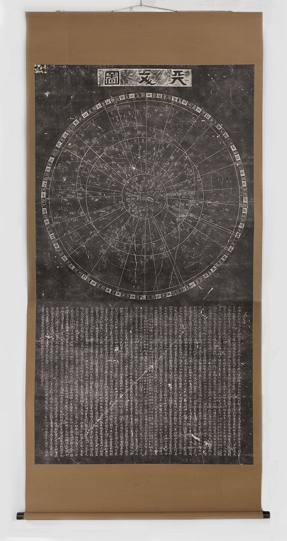
http://www.atlascoelestis.com/Wang%201193-1247.htm
e
Kwon Geun
Cheonsang Yeolcha Bunyajido 천상열차분야지도 ; 天象列次分野之圖, Corea 1396 circa
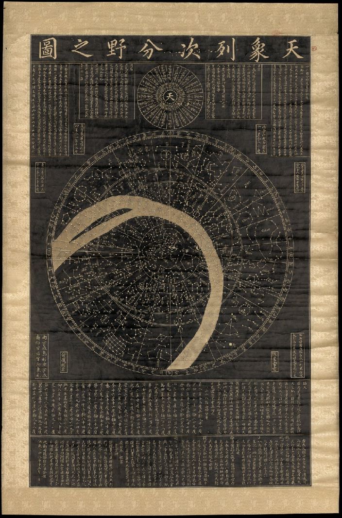
http://www.atlascoelestis.com/Coreano%201396.htm
e
Johann Adam Schall von Bell
Xu Guangqi ( Hsû Kuang-ch'i)
Due carte generali delle stelle al nord e al sud dell'equatore, Cina 1634
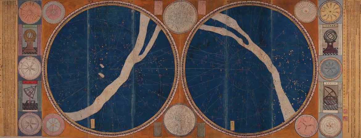
http://www.atlascoelestis.com/Schall%201634.htm
e
Johann Adam Schall von Bell
Xu Guangqi ( Hsû Kuang-ch'i)
Hsi Yang Hsin Fa Li Shu, Compendio sul calendario secondo il nuovo metodo occidentale, Pechino 1645
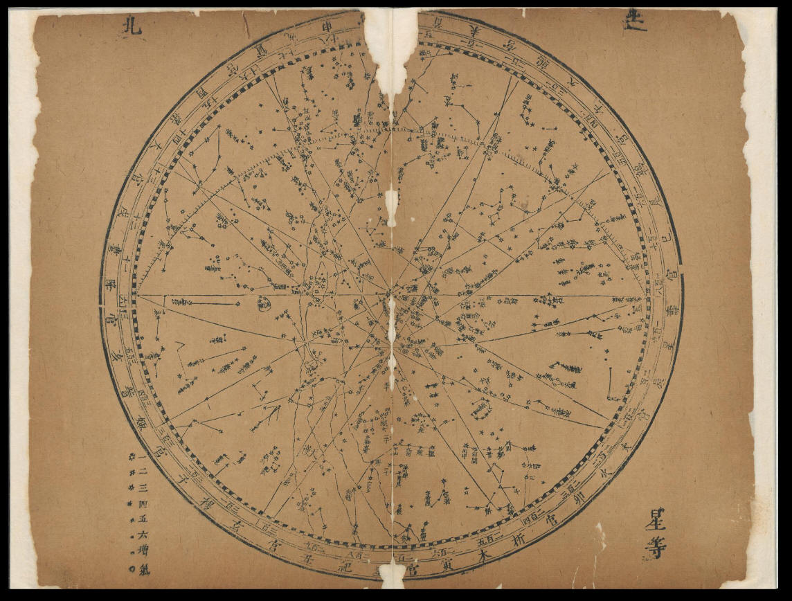
http://www.atlascoelestis.com/Schall%201645.htm
e
Yunyou Sanren 雲遊散人 e Huang Shang 黃裳
Huntian yitong xingxiang quantu 渾天壹統星象全圖 [Complete Celestial Chart] , China 1822
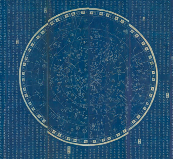
http://www.atlascoelestis.com/Yunyou%201822.htm
e
Gustav Schlegel
Uranographie Chinoise, Atlas Céleste Chinois et Grec d’après le Tien-Youen Li-Li, La Haye e Leyde 1875
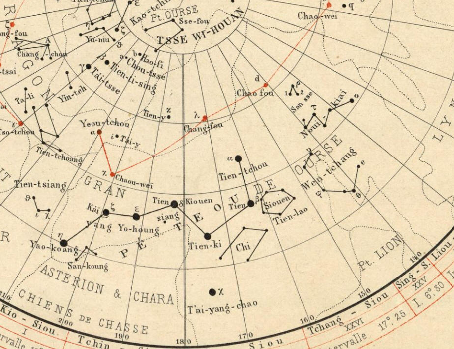
http://www.atlascoelestis.com/Schlegel%201875.htm
e
Claudio Filippo Grimaldi, Min Mingwo Dexian
Fang-sing-tou-kiai: Explication de les Tables de toutes les étoiles, Pechino 1711
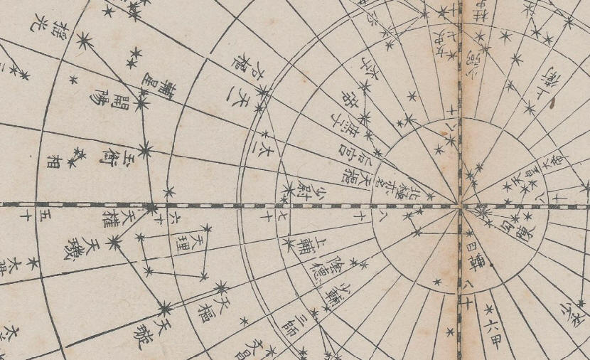
http://www.atlascoelestis.com/grimaldi%201711.htm
e
Tae-Tsen-Hsun
Carta celeste e del Sistema Solare, Cina 1723 circa
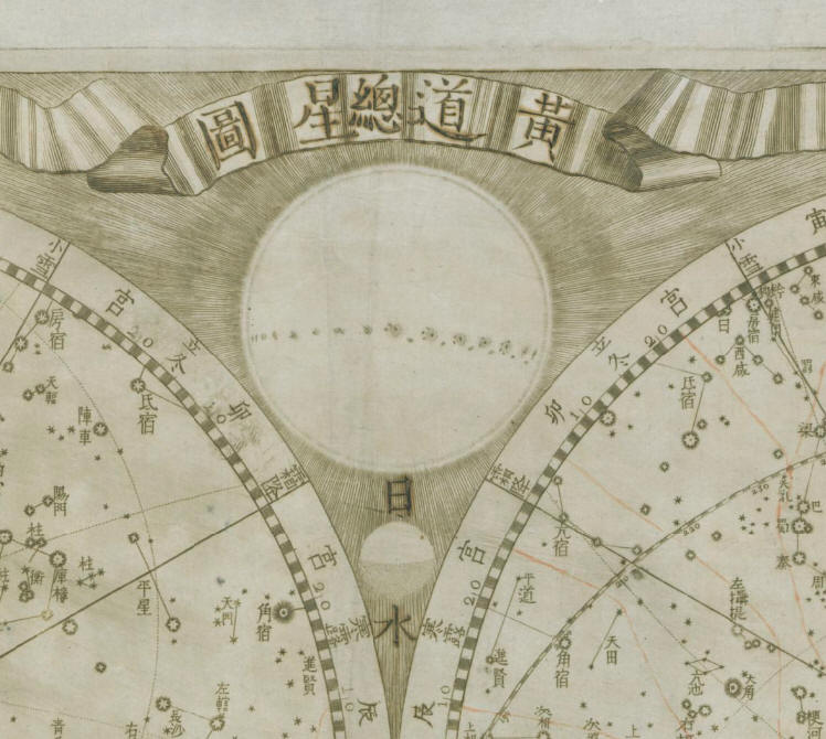
http://www.atlascoelestis.com/Thetsen%201723.htm
e
Jean-François Foucquet
Pro confirmatione systematis temporum propheticorum, hoc planispherium est in duplici, nempe in recto et in verso situ contemplandum. Hémisphère céleste boréal avec légende en chinois et annotations manuscrites en latin, Francia 1722 circa
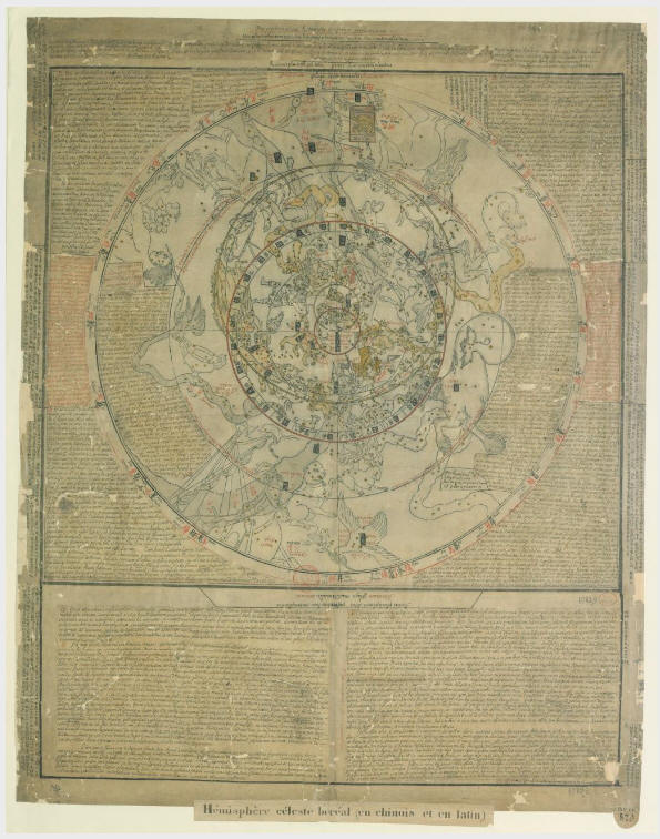
http://www.atlascoelestis.com/Foucquet%201822.htm
Sull'astronomia cinese, le costellazioni e la rappresentazione del cielo confrontati con il sistema occidentale puoi leggere:
Chrétien-Louis Joseph De Guignes
Planisphère céleste chinois. Partie Septentrionale. Paris 1785
Planisphère céleste chinois. Partie Meridionale, Paris 1785
in
Mèmoires de Mathematique et de Physique, Présentés a l'Académie Royal des Sciences, Par Divers Savans (Etrangers), Vol 10, Paris 1785
http://www.atlascoelestis.com/Deguignes%20home.htm
Elenco di alcune voci in Wikipedia che trattano la
cartografia celeste orientale
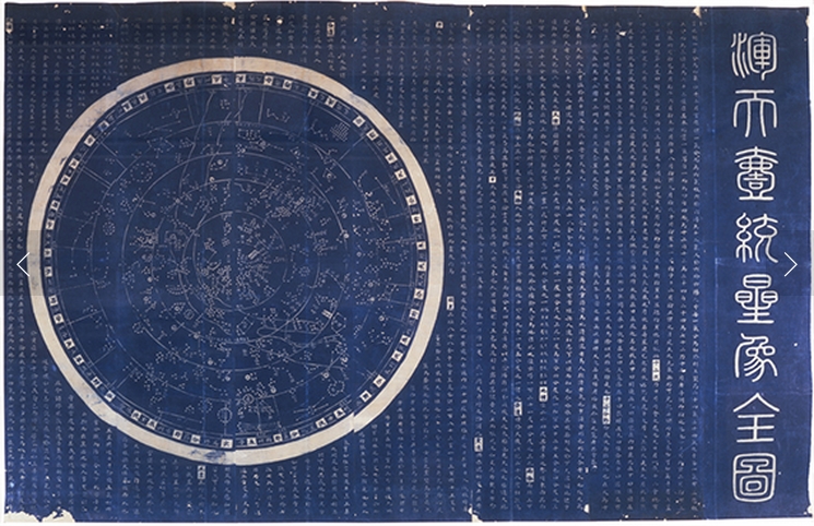
http://www.wikiwand.com/en/Chinese_star_maps#
http://en.wikipedia.org/wiki/Traditional_Chinese_star_names
http://en.wikipedia.org/wiki/Chinese_constellations
http://en.wikipedia.org/wiki/Chinese_star_maps
http://en.wikipedia.org/wiki/Nakshatra
http://www.asahi-net.or.jp/~nr8c-ab/kttyokoseizu1.htm
Ian Ridpath, Charting the Chinese sky
http://www.ianridpath.com/startales/chinese.htm
e
a cura di IDP, International Dunhuang Project
History of Astronomy in China

http://idp.bl.uk/education/astronomy/history.html
di FELICE STOPPA
DICEMBRE 2013