|
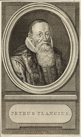
Petrus Plancius |
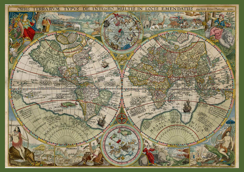
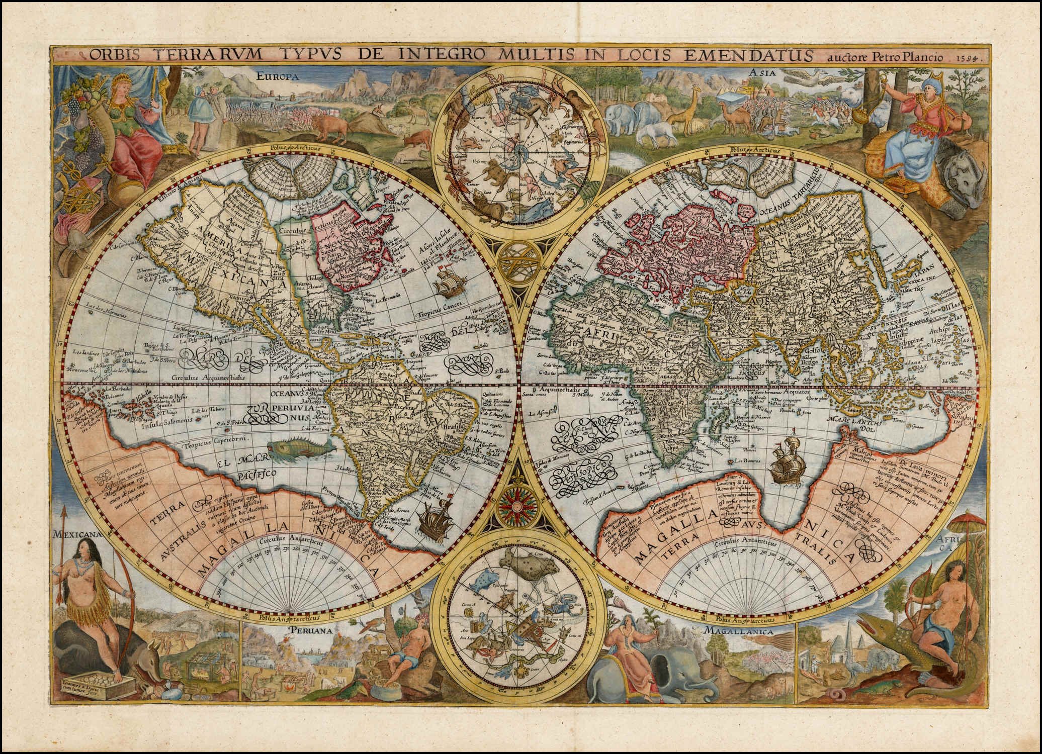
Orbis
Terrarum Typus De Integro Multis in Locis Emendatus, |
Petrus
Plancius
Orbis
Terrarum Typus De Integro Multis in Locis Emendatus,
continua dalla pagina principale
"This
new world map by Petrus Plancius was first issued separately in 1595 or shortly
thereafter and then later incorporated into editions of Linschoten's Itinerarium
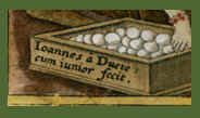
from 1599 onwards. It has been angraved by Jan van Doetecum, a craftsman of
great skill whose signature appears in the lower left-hand corner and who was
associated with a number of Plancius' maps.
The two main terrestial hemispheres are based on those in Plancius' earlier
world map of 1590, updated by geographical detail and with the addition of two
celestial spheres from his large wall map two years later. The
Inscriptions in the arctic show that Plancius was aware of reports of English
voyages there and, perhaps to encourage forthcoming expeditions, Novaya Zemlaya
is newly shown as an island. Koeman, writing in his introduction to Jodocus
Hondius' Wall-Map of Europe 1595 (Amsterdam, 1967) says of Plancius' map
that 'Some copies show traces of the correction of an earlier edition in
which the Arctic continent has been revised in order to depict the islands of
Novaya Zemlaya'. I have not seen an unrevised state, and it is usually
accepted that Barentsz.' voyages of 1594 were forst portrayed on the twin
hemispheres which Hondius portrayed on his large map of Europe the following
year, 1595.
The elaborate pictorial borders were inspired by drawings in the works of
Theodore de Bry published a few years earlier and established a pattern of
cartographical decoration that lasted over a century. The regions of the world
are exemplified by means of symbolic female figures, by landscape vignettes, and
by lively pictures of animals indigenous to each area. Doetecum has included
elephants and camels, a giraffe, a unicorn, an ostrich and the footless bird of
paradise; parrots, snakes and monkeys and - as unlikely beasts of transport for
the regional figures - a rhinoceros, a crocodile and a giant armadillo. Europe
and Asia are thus shown along the top of the map and Africa, Magellanica,
Plancius' map had a widespread influence on other map-makers and it was issued
unchanged throughout the various editions of Linschoten's Itinerarium
from 1599 onwards. It is therefore occasionally available to collectors."
(Shirley).
"The
first World Map with elaborate, pictorial borders.
This beautiful map from Linschoten's Voyages combines the skills of two
of the most respected map makers and engravers of the day. Petrus Plancius and
Jan van Doetichum, whose signature is visible at the lower left, worked together
on many map productions and this is one of their best known.
This map is the first to use elaborate pictorial borders representing the
peoples, animals and environment of foreign parts and established a tradition
which was maintained by most Dutch map makers throughout the next century and by
numerous others of various nations over the next two hundred years.
In each corner are female representations of the four continents: Europe, an
elegant crowned figure holding a cornucopia and a sceptre, a helmet, a lute and
symbols of wisdom at her feet; Asia, an elaborately robed figure seated on a
rhinoceros and holding an incense burner, a casket of baubles at her feet;
Africa, an almost naked figure riding a crocodile armed with bow and arrows;
America, entitled Mexicana, an Amazon figure seated on an armadillo.
Between the figures and the celestial spheres at top and bottom are further
illustrations of the animals, people and habitations of these exotic places.
Much of the illustration here, as in numerous Dutch map design was inspired by
the illustrations in the reports published by de Bry a few years earlier.
This map by Plancius was copied almost line-for-line by others but a few of the
subsequent seventeenth-century World maps came close to matching this for a
combination of content and decoration."
(Potter).
"Similar
maps of this two-hemisphere type, with elaborate pictorial borders inspired by
Théodore de Bry's collection of travelers' tales, were popular for a century or
more after Plancius introduced his 1594 map. It in turn was based on Mercator's
two-hemisphere world map of 1587. The northern and southern celestial
hemispheres came from Plancius's owm large world map of 1592. The changes
Plancius made both to Mercator's map and to his own precursors of the 1594 map
seen to have been introduced partly to make the idea of a sea route to Asia
through the arctic appear more attractive, for Plancius was waging a personal
campaign to promote Dutch penetration into Far Eastern markets.
The first Dutch landfall in Australia was not made until 1606, so that
Magellanica was still filled with details drawn from the by then centuries-old
stories of travelers like the Polos and Lodovico di Varthema; note Marco Polo's Lucach,
Beach, and Maletur. Nevertheless, farther to the north Java,
Borneo, and the
(Tooley &
Bricker).
Ho
presentato nelle righe precedenti la carta di Plancius del 1594 con tre
riferimenti bibliografici presenti sul sito di Leen
Elmink, Antique Maps, antiquario che ha avuto la fortuna di possedere e
mettere in vendita una delle rare copie originali dell’opera.
La
tavola dei due emisferi terrestri (cm 40,5 per 57,5) nell’edizione che
presento riporta nella sua parte centrale, in alto e in basso, anche la
rappresentazione dei due emisferi celesti (8,5cm di diametro) calcolati per il
1594. La tavola prodotta e messa in vendita separatamente nel 1594 fu poi
inserita nell’Itinerario di J. H.
Linschoten del 1596. Nell’angolo in basso a sinistra troviamo il riferimento
all’incisore: Ioannes à Deutecum
iunior fecit.
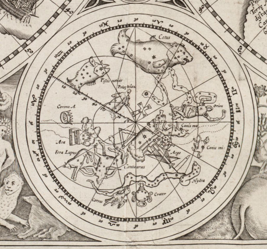
I due emisferi celesti sono stati prodotti in proiezione stereografica convessa e hanno come riferimento i due poli eclittici, la circonferenza esterna è rappresentata dall’Eclittica, graduata con tacche di un grado di longitudine e suddivisa in 12 spicchi di 30°, il reticolo eclittico è completato da altrettante 12 linee di longitudine, quelle dei solstizi sono graduate con tacche di un grado di latitudine. Il reticolo polare equatoriale comprende i due poli, i circoli polari, i circoli dei tropici, i coluri e l’equatore. Nell’emisfero sud è ben demarcato il tracciato della Via Lattea. Le costellazioni zodiacali sono riportate soltanto nell’emisfero boreale, sul bordo dell’eclittica. Avendo uno scopo didascalico i due emisferi presentano poche stelle, non distinte in classi di grandezze, e soltanto una parte delle costellazioni tolemaiche. Oltre a queste, denominate in latino, risaltano le seguenti costellazioni non tolemaiche: Emisfero boreale - Cesaries. Emisfero australe - Columba, la costellazione di fantasia denominata Polophilax, quindi Crux, Triangulum Australe e le due Nubi di Magellano in posizione di fantasia ad occupare la zona di cielo invisibile dalle latitudini europee.

TAVOLA


https://collections.leventhalmap.org/search/commonwealth:3f462s46z
BIOGRAFIA DI PETRUS PLANCIUS
PER CORTESIA DI WIKIPEDIA
Costruisci il
Nocturnal Celestial Globe di
Petrus Plancius

per cortesia di
Giuseppe (Pino) Civitarese
di FELICE STOPPA