|
Conrad of Dyffenbach
MS
Palat. Lat. 1368. ff. 63v-64r, Città del Vaticano, Heidelberg 1426
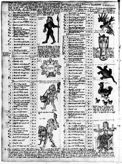
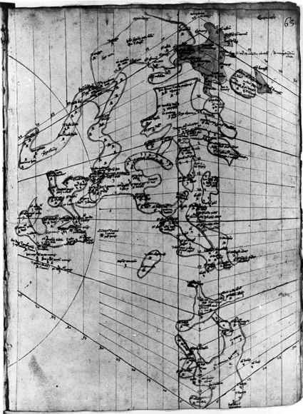
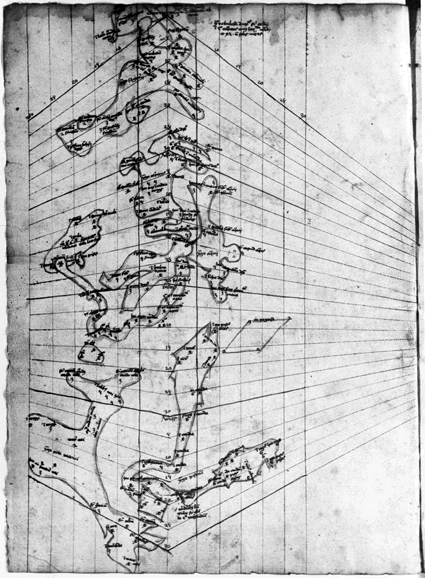
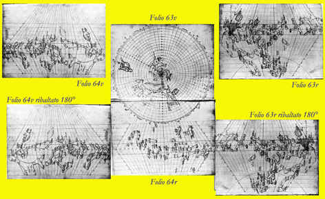
Le quattro tavole contenute in altrettanti quattro fogli manoscritti
raccolti nel codice Vat Lat 1368 sono probabilmente la prima
rappresentazione
del cielo stellato su carta
di epoca moderna. Le
tavole, una volta accostate, rappresentano tutta la volta boreale e gran
parte di quella australe conosciuta. Le
due mappe contenute nei fogli 63v e 64 r sono in proiezione convessa, quelle
rappresentate in 63r e 64v in proiezione concava. Queste ultime pertanto,
per poter essere unite con continuità alle altre, devono essere ribaltate
di 180° sul loro asse verticale. Per l’emisfero nord , contenuto nel
foglio 63v e completato in 64 r, l’autore utilizza una proiezione polare
eclittica equidistante, per le altre tre tavole la proiezione è quella
trapezoidale ed è stata personalmente progettata da Dyffenbach. La seguente presentazione è di Anna Friedman
Herlihy ed è tratta dal suo saggio Renaissance
Star Charts contenuto nell’enciclopedica opera dedicata alla storia
della cartografia edita nel The History of
Cartography,
The University of Chicago Press, http://www.press.uchicago.edu/books/HOC/HOC_V3_Pt2/Volume3_Part2.html “The earliest extant twodimensional star maps other
than astrolabes with identifiable projections appear to be those in the
Vatican library manuscript attributed to the copyist Conrad of Dyffenbach
and dated 1426.38 This manuscript contains four maps that chart a
limited number of stars with sketchedin outlines of selected
constellations. The star catalog information derives from Gerard of 38. Vatican
City, Biblioteca Apostolica Vaticana (Codex Palat. Lat. 1368), 63r, 63v, 64r, and 64v. For detailed
information on these maps, see Dana Bennett Durand, The
Vienna-Klosterneuburg Map Corpus of 39. Kunitzsch, “Astronomer Abu ’l-H. usayn al-S.u— fı—,”
67, n. 36. 40. Durand, Vienna-Klosterneuberg, 115. 41. Durand suggests that this projection may have come from an Arabic source, possibly Abu— al-Rayh. a—n Muh.ammad ibn Ah. mad al-Bı—ru—nı— (Vienna-Klosterneuberg, 116).”
di Anna Friedman Herlihy Herlihy Conrad of dyffenbach 1426.pdf
Nel volume Illustrating the Phaenomena, Celestial Cartography in Antiquity and the Middle Ages, Oxford University Press, 2013, l’autrice Elly Dekker dedica alle tavole di Dyffenbach una ampia e approfondita presentazione che pubblico per intero per cortesia di Google Libri Digitali.
L’intero manoscritto di cui fanno parte i quattro fogli può essere consultato alla seguente pagina contenuta in The Warburg Institute, Iconographic Database:
Fol 51v
Due delle tavole di Dyffenbach sono riprodotte a pag. 165 del primo volume e a pag. 23 del secondo volume di Fritz Saxl Verzeichnis astrologischer und mythologischer illustrierter Handschriften des lateinischen Mittelalters, Heidelberg 1927 proposto interamente di seguito Saxl verzeichnisastro00saxl.pdf
|
in costruzione FOLIO 63v
FOLIO 63 r
FOLIO 64 r
FOLIO 64 v
Ricostruzione completa
di FELICE STOPPA APRILE 2014
|