|
Arthur Cottam |
CHARTS OF THE CONSTELLATIONS from the North Pole to between 35 & 40 degrees of south declination, London 1891
|
Arthur Cottam
CHARTS OF THE CONSTELLATIONS from the North Pole to between 35 & 40 degrees of south declination, London 1891
Riedizione del 1891 dell’atlante realizzato da A. Cottam nel 1889 in due formati: Una edizione "popolare" (15 per 22 pollici) e una edizione in tiratura limitata di 200 copie in cartellina contenente 36 doppie pagine ( 30 per 22 pollici).
L'atlante riproduce tutte le costellazioni dell’emisfero boreale e parte di quello australe fino ad una declinazione di -35° -40°.


https://www.abebooks.com/first-edition/Charts-Constellations-North-Pole-Degrees-South/7472624717/bd

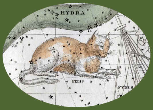
Nell'edizione del 1891 vengono aggiunte altre tre tavole riassuntive della zona celeste considerata. La posizione delle 3785 stelle ( comprendenti quelle visibili ad occhio nudo fino alla 6,5 magnitudine e con l’aggiunta di ulteriori altri visibili solo al telescopio) è calcolata per il 1890. L’edizione è preceduta da una introduzione.
Le prime tre tavole, Key map N°1,2,3 sono riassuntive: la prima é incentrata sul polo nord celeste equatoriale e si estende fino alla declinazione di +40°; la seconda e la terza riproducono tutta la fascia equatoriale dalla declinazione di +55° a -40°.
Tutte le altre tavole, dalla N° 1 alla N° 33, sono dedicate alle 57 costellazioni che l’autore ha considerato ponendo i loro nomi come titolo delle relative mappe.
Di seguito possiamo leggere una recensione della prima edizione pubblicata su
Nature del Nov, 14, 1889:


https://www.nature.com/articles/041045a0.pdf
e ripresa in
THE MAP HOUSE


Here the charts are described in Nature, “.. a series of thirty-six most excellent charts of the constellations from the North Pole to between 35° and 40° of south declination, and showing stars in half magnitudes down to 6 1/2 by disks of various sizes. Although the primary object in constructing these charts was to make them companions to Webb’s ‘Celestial Objects for Common Telescopes’ and Smyth’s ‘Cycle of Celestial Objects’, their scope has been considerably enlarged, and a number of double, multiple, and variable stars have been laid down which are not included in either of the above-mentioned works. The Earl of Crawford’s (Dun Echt) summary of F.G.W. Struve’s Dorpat Catalogue included 2248 double and multiple stars, and of them, 2130 are shown upon these charts. In addition to this, 275 of the double stars discovered by Mr. S.W. Burnham have been mapped, this being the whole of those included in his first four catalogues, and a selection from his other catalogues. The maps have been drawn to a scale of one-third of an inch to a degree, which is a much larger scale than any hitherto published, and as each map includes but a small portion of the heavens, there is practically no distortion, whilst the epoch being 1890, the positions will hold good, without any serious errors, for fifteen or twenty years beyond that date. The projection is conical, or, in those charts which extend any distance both north and south of the equator, cylindrical. Hence it will be easy to lay down any additional objects that may be required. There is no doubt that these charts will be eminently useful, one of their great advantages being that they will enable possessors of telescopes mounted on altazimuth stands or without circles to find with ease a large number of interesting objects, and thus will help to extend the knowledge of the heavenly bodies and to popularize the most fascinating of sciences.”.
https://blog.themaphouse.com/2015/04/24/arthur-cottams-star-maps/
Scheda biografica di Arthur Cottam

http://www.microscopist.net/CottamA.html
Le tavole dell’atlante del 1891
Per cortesia della
Latvijas Universitate di Riga in Lettonia


L'Università di Riga possiede e propone in visione oltre 40 atlanti celesti di autore consultabili alla seguente pagina:
di FELICE STOPPA
OTTOBRE 2023