|
Joan
Blaeu
Nova
totius terrarum orbis
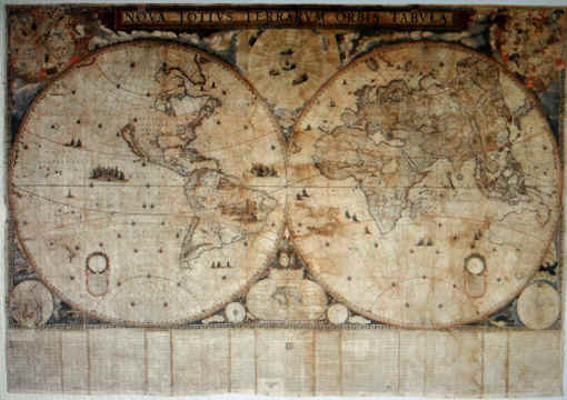
La grande mappa di Blaeu
è incisa su 21 indipendenti fogli, riuniti insieme ed incollati sopra una
tela di lino delle dimensioni di
205 cm
x
299 cm
.
Negli angoli superiori
sono riportati i due emisferi celesti, di
35 cm
di diametro.
Per
cortesia di
The Kraus Map Collection
http://norman.hrc.utexas.edu/krausmaps/
http://norman.hrc.utexas.edu/krausmaps/details.cfm?mapId=11:
riporto
di seguito la scheda in inglese che illustra la mappa:
Engraved
map, with contemporary, probably original, with hand coloring.
On
21 large folio sheets, joined together and laid down on linen. Contemporary
silk tapes sewn to the lateral edges.
The
map measures 2043 x
2995 mm
. (including text which measures 360 x
299 mm
.)
Despite
the fact that it exists in two quite distinct states, only two complete
copies of the map, with the accompanying text, are known to exist; the
present one, in the first state, and the one in the Amsterdam Scheepvaarts
Museum, which is in the second state. A copy in the Royal Geographical
Society, London, does not have the text, and is of the second state. A
copy which has been cut down to just the two large hemispheres, and which
therefore lacks the text, the eight subsidiary marginal maps and
astronomical figures, and the decorative engraving, is in the giant
Charles II Atlas in the British Museum. A similar cut-down pair of
hemispheres (of the second state) is, or was, in a similar big volume in
Berlin - it also is of august provenance, being a volume presented by
Johann Mauritius of Nassau-Siegen to the Elector Friedrich Wilhelm of
Prussia, c. 1661. The BM volume was a present from the merchants of
Amsterdam to the exiled King Charles II during Commonwealth days.
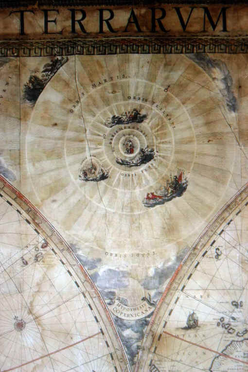
DESCRIPTION OF THE MAP
The map is dominated by the two world-hemispheres (
1440 mm
. diameter); in the upper corners are the northern and southern celestial
hemispheres; upper center, a representation of the Copernican
world-system. In the lower corners are displayed the northern and southern
polar regions, the latter a blank except for the southern tip of South
America. This abandonment of the "Terra Australis Incognita"
represents a remarkable advance in geographical knowledge. In the lower
center is a map of the world as it was known in Europe in the year 1490,
just before the era of oceanic voyaging, showing the Mediterranean world
of the ancients plus the discoveries of the African shores southwards and
the Atlantic islands, made in the late Middle Ages. This is flanked by
representations of the Ptolemaic and Tychonian world systems. Above the
"1490" map is the dedication to Gaspar de Brancamonte y Guzman,
Count of Peñaranda, Spanish Ambassador to the peace conference of
Muenster in Westphalia. Wieder infers from the wording of this dedication
that the map was issued in 1648, the year of the peace treaty of
Westphalia. In the lower corners are figures of a salamander, a whale, a
mole, and an eagle, symbolizing the four elements. The text below the map
is, according to Wieder, "a simple and useful explanation of the
fundamentals of geography as it was understood in those days." It is
in Latin and French.
THE TASMAN AND VRIES
DISCOVERIES
The map is important not only for its extraordinary size and beauty, but
as a first recording of important geographical discoveries. Abel Jansz
Tasman, the great Dutch navigator, carried out in 1642-1644 two voyages of
exploration which are among the most notable ever made. Another notable
Dutch explorer whose discoveries first appear on this map is Maerten
Gerritsz Vries.
FIRST AND SECOND ISSUES OF
THE MAP
In 1920, Mr. Edward Heawood made a detailed comparison of the Royal
Geographical Society and the British Museum examples of the map. He
discovered that the portion depicting China existed in two states. While
the differences in detail are very numerous, the first issue may be
recognized at a glance by the fact that the Shantung Peninsula is entirely
absent. The second state must have appeared years later than the first;
while the first came out probably in 1648, the second is based upon the
cartography of the Jesuit M. Martini, who returned to Europe from China
only in 1654, and whose general geography of China was published by Blaeu
only in 1659. The second issue is therefore at least 6-10 years after the
first, and perhaps even later.
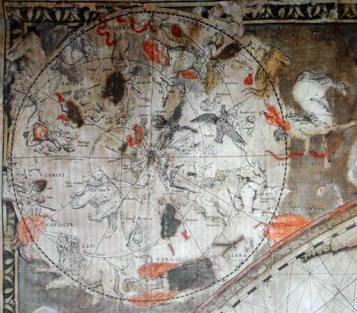
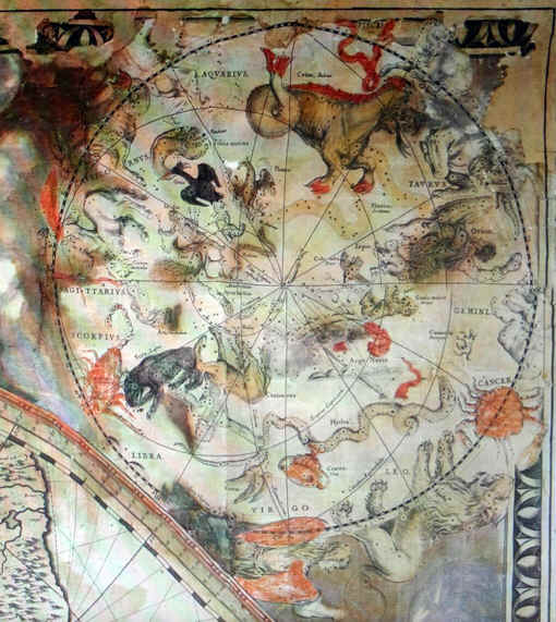
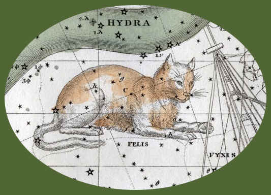
Gli
emisferi celesti
Sono in proiezione
stereografica ed in visione convessa, si estendono dai poli eclittici fino
all’eclittica che fa da
circonferenza. In entrambe le mappe sono riprodotte,
sopra l’eclittica, le costellazioni zodiacali. Misurano
35 cm
di diametro. La tavola è stata prodotta nel 1648 e le stelle vi sono
posizionate per il 1600.
Il reticolo di riferimento
principale è quello eclittico e comprende i Poli, l’Eclittica, graduata
al passo di un grado di longitudine i cui gradi sono numerati di
10 in
10; la numerazione si ripete ogni 30 gradi in corrispondenza del relativo
raggio di longitudine.
Il reticolo equatoriale è
composto dai poli e dai circoli polari (Artico ed Antartico) dai cerchi
dei Tropici (del Cancro e del Capricorno), dalle linee dei Coluri e dalle
rispettive frazioni del circolo equatoriale.
Oltre alle costellazioni tolemaiche sono rappresentate quelle di Antinous,
Caput
Medusae e di Coma Berenices per
l’emisfero boreale e per l’emisfero australe quelle di El Crusero, Colomba Noe e
tutte le costellazioni introdotte nell’Uranometria
del Bayer nel 1603 e scoperte nell’ultima parte del cinquecento dai
navigatori Keyser ed Houtman, di queste costellazioni manca però quella
del Triangulum Australe.
Le
costellazioni sono denominate in latino e per le stelle principali viene
riportato il nome proprio.
|